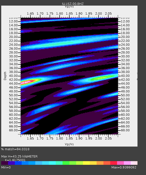
LSZ Lusaka, Zambia - Earthquake Result Viewer

Earthquake location: South Sandwich Islands Region
Earthquake latitude/longitude: -60.2/-26.9
Earthquake time(UTC): 2009/04/16 (106) 14:57:06 GMT
Earthquake Depth: 20 km
Earthquake Magnitude: 6.2 MB, 6.8 MS, 6.7 MW, 6.7 MW
Earthquake Catalog/Contributor: WHDF/NEIC
Network: IU Global Seismograph Network (GSN - IRIS/USGS)
Station: LSZ Lusaka, Zambia
Lat/Lon: 15.28 S/28.19 E
Elevation: 1200 m
Distance: 59.8 deg
Az: 66.239 deg
Baz: 208.27 deg
Ray Param: 0.06192773
Estimated Moho Depth: 43.25 km
Estimated Crust Vp/Vs: 1.62
Assumed Crust Vp: 6.642 km/s
Estimated Crust Vs: 4.106 km/s
Estimated Crust Poisson's Ratio: 0.19
Radial Match: 94.0318 %
Radial Bump: 400
Transverse Match: 83.04917 %
Transverse Bump: 400
SOD ConfigId: 2658
Insert Time: 2010-03-02 15:24:03.358 +0000
GWidth: 2.5
Max Bumps: 400
Tol: 0.001

Signal To Noise

ChannelStoNSTALTA
IU:LSZ:00:BHZ:20090416T15:06:38.918994Z2.8144143.054361E-71.0852564E-7
IU:LSZ:00:BHN:20090416T15:06:38.918994Z0.95230381.7022342E-71.7874906E-7
IU:LSZ:00:BHE:20090416T15:06:38.918994Z1.03978771.4908639E-71.4338157E-7
Arrivals
Ps4.3 SECOND
PpPs16 SECOND
PsPs/PpSs20 SECOND