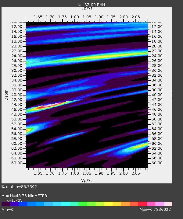
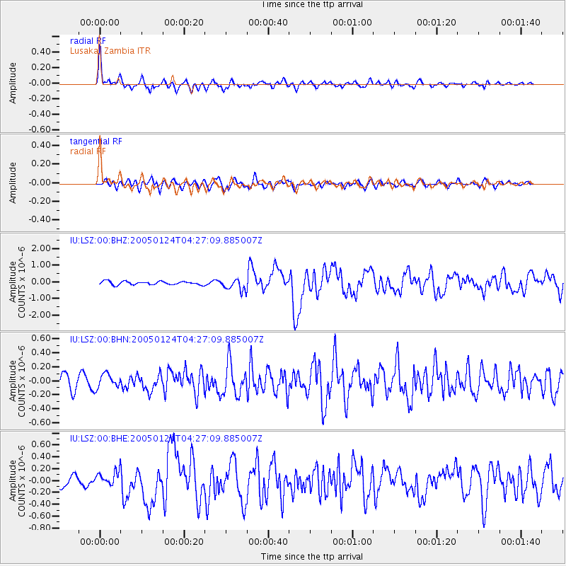
LSZ Lusaka, Zambia - Earthquake Result Viewer

Earthquake location: Nicobar Islands, India Region
Earthquake latitude/longitude: 7.3/92.5
Earthquake time(UTC): 2005/01/24 (024) 04:16:47 GMT
Earthquake Depth: 30 km
Earthquake Magnitude: 6.1 MB, 6.2 MS, 6.3 MW, 6.2 MW
Earthquake Catalog/Contributor: WHDF/NEIC
Network: IU Global Seismograph Network (GSN - IRIS/USGS)
Station: LSZ Lusaka, Zambia
Lat/Lon: 15.28 S/28.19 E
Elevation: 1184 m
Distance: 67.5 deg
Az: 250.217 deg
Baz: 75.27 deg
Ray Param: 0.056846797
Estimated Moho Depth: 43.75 km
Estimated Crust Vp/Vs: 1.71
Assumed Crust Vp: 6.642 km/s
Estimated Crust Vs: 3.896 km/s
Estimated Crust Poisson's Ratio: 0.24
Radial Match: 86.7302 %
Radial Bump: 400
Transverse Match: 65.81674 %
Transverse Bump: 400
SOD ConfigId: 5233
Insert Time: 2010-03-02 15:24:23.541 +0000
GWidth: 2.5
Max Bumps: 400
Tol: 0.001

Signal To Noise

ChannelStoNSTALTA
IU:LSZ:00:BHN:20050124T04:27:09.885007Z0.93516359.933269E-81.062196E-7
IU:LSZ:00:BHE:20050124T04:27:09.885007Z1.13890661.2624977E-71.1085174E-7
IU:LSZ:00:BHZ:20050124T04:27:09.885007Z3.57491613.6134853E-71.0107888E-7
Arrivals
Ps4.9 SECOND
PpPs17 SECOND
PsPs/PpSs22 SECOND