You are here: Home > Network List > AU - Australian Seismological Centre Stations List
> Station MUN Mundaring, Western Australia > Earthquake Result Viewer
MUN Mundaring, Western Australia - Earthquake Result Viewer
| Earthquake location: |
Solomon Islands |
| Earthquake latitude/longitude: |
-11.2/163.2 |
| Earthquake time(UTC): |
2015/05/22 (142) 23:59:33 GMT |
| Earthquake Depth: |
10 km |
| Earthquake Magnitude: |
6.8 MO |
| Earthquake Catalog/Contributor: |
NEIC PDE/NEIC ALERT |
|
| Network: |
AU Australian Seismological Centre |
| Station: |
MUN Mundaring, Western Australia |
| Lat/Lon: |
31.98 S/116.21 E |
| Elevation: |
253 m |
|
| Distance: |
47.9 deg |
| Az: |
236.856 deg |
| Baz: |
75.21 deg |
| Ray Param: |
0.06969028 |
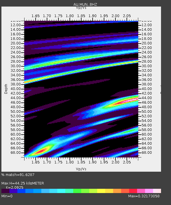
| Estimated Moho Depth: |
44.25 km |
| Estimated Crust Vp/Vs: |
2.09 |
| Assumed Crust Vp: |
6.419 km/s |
| Estimated Crust Vs: |
3.068 km/s |
| Estimated Crust Poisson's Ratio: |
0.35 |
|
| Radial Match: |
91.6287 % |
| Radial Bump: |
225 |
| Transverse Match: |
76.771194 % |
| Transverse Bump: |
400 |
| SOD ConfigId: |
7422571 |
| Insert Time: |
2019-04-19 00:41:33.152 +0000 |
| GWidth: |
2.5 |
| Max Bumps: |
400 |
| Tol: |
0.001 |
|

Signal To Noise
| Channel | StoN | STA | LTA |
| AU:MUN: :BHZ:20150523T00:07:41.168988Z | 3.0357225 | 2.026596E-6 | 6.6758275E-7 |
| AU:MUN: :BHN:20150523T00:07:41.168988Z | 1.0088872 | 1.9703121E-7 | 1.9529557E-7 |
| AU:MUN: :BHE:20150523T00:07:41.168988Z | 5.559487 | 1.8693233E-6 | 3.3624028E-7 |
| Arrivals |
| Ps | 7.9 SECOND |
| PpPs | 20 SECOND |
| PsPs/PpSs | 28 SECOND |


