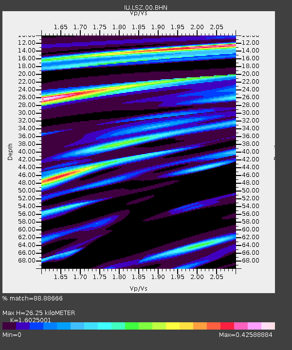
LSZ Lusaka, Zambia - Earthquake Result Viewer

Earthquake location: Southwest Of Sumatra, Indonesia
Earthquake latitude/longitude: -6.2/103.1
Earthquake time(UTC): 2005/05/10 (130) 01:09:05 GMT
Earthquake Depth: 17 km
Earthquake Magnitude: 5.9 MB, 6.4 MS, 6.2 MW, 6.2 MW
Earthquake Catalog/Contributor: WHDF/NEIC
Network: IU Global Seismograph Network (GSN - IRIS/USGS)
Station: LSZ Lusaka, Zambia
Lat/Lon: 15.28 S/28.19 E
Elevation: 1184 m
Distance: 73.9 deg
Az: 255.946 deg
Baz: 92.17 deg
Ray Param: 0.05268257
Estimated Moho Depth: 26.25 km
Estimated Crust Vp/Vs: 1.60
Assumed Crust Vp: 6.642 km/s
Estimated Crust Vs: 4.145 km/s
Estimated Crust Poisson's Ratio: 0.18
Radial Match: 88.88666 %
Radial Bump: 393
Transverse Match: 77.138176 %
Transverse Bump: 400
SOD ConfigId: 2455
Insert Time: 2010-03-02 15:24:45.238 +0000
GWidth: 2.5
Max Bumps: 400
Tol: 0.001

Signal To Noise

ChannelStoNSTALTA
IU:LSZ:00:BHN:20050510T01:20:07.761011Z1.07127231.419288E-71.324862E-7
IU:LSZ:00:BHE:20050510T01:20:07.761011Z3.65872485.432976E-71.484937E-7
IU:LSZ:00:BHZ:20050510T01:20:07.761011Z6.6780061.2740201E-61.9077851E-7
Arrivals
Ps2.5 SECOND
PpPs9.9 SECOND
PsPs/PpSs12 SECOND