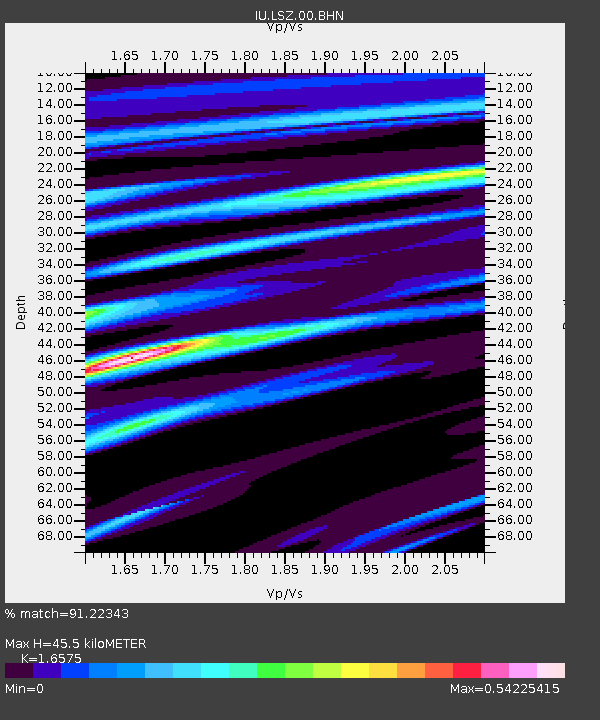
LSZ Lusaka, Zambia - Earthquake Result Viewer

Earthquake location: Northern Sumatra, Indonesia
Earthquake latitude/longitude: 1.8/97.1
Earthquake time(UTC): 2005/07/05 (186) 01:52:02 GMT
Earthquake Depth: 21 km
Earthquake Magnitude: 6.2 MB, 6.8 MS, 6.7 MW, 6.6 MW
Earthquake Catalog/Contributor: WHDF/NEIC
Network: IU Global Seismograph Network (GSN - IRIS/USGS)
Station: LSZ Lusaka, Zambia
Lat/Lon: 15.28 S/28.19 E
Elevation: 1184 m
Distance: 70.2 deg
Az: 253.152 deg
Baz: 82.385 deg
Ray Param: 0.05513316
Estimated Moho Depth: 45.5 km
Estimated Crust Vp/Vs: 1.66
Assumed Crust Vp: 6.642 km/s
Estimated Crust Vs: 4.007 km/s
Estimated Crust Poisson's Ratio: 0.21
Radial Match: 91.22343 %
Radial Bump: 351
Transverse Match: 73.56316 %
Transverse Bump: 400
SOD ConfigId: 2475
Insert Time: 2010-03-02 15:24:48.909 +0000
GWidth: 2.5
Max Bumps: 400
Tol: 0.001

Signal To Noise

ChannelStoNSTALTA
IU:LSZ:00:BHN:20050705T02:02:42.84801Z1.49402431.5081254E-71.0094383E-7
IU:LSZ:00:BHE:20050705T02:02:42.84801Z1.98772933.8786837E-71.9513139E-7
IU:LSZ:00:BHZ:20050705T02:02:42.84801Z5.44515561.0066472E-61.8487025E-7
Arrivals
Ps4.7 SECOND
PpPs17 SECOND
PsPs/PpSs22 SECOND