You are here: Home > Network List > TA - USArray Transportable Network (new EarthScope stations) Stations List
> Station J05D Fort Rock, OR, USA > Earthquake Result Viewer
J05D Fort Rock, OR, USA - Earthquake Result Viewer
| Earthquake location: |
Solomon Islands |
| Earthquake latitude/longitude: |
-11.2/163.2 |
| Earthquake time(UTC): |
2015/05/22 (142) 23:59:33 GMT |
| Earthquake Depth: |
10 km |
| Earthquake Magnitude: |
6.8 MO |
| Earthquake Catalog/Contributor: |
NEIC PDE/NEIC ALERT |
|
| Network: |
TA USArray Transportable Network (new EarthScope stations) |
| Station: |
J05D Fort Rock, OR, USA |
| Lat/Lon: |
43.28 N/121.23 W |
| Elevation: |
1541 m |
|
| Distance: |
87.3 deg |
| Az: |
45.073 deg |
| Baz: |
252.074 deg |
| Ray Param: |
0.043426074 |
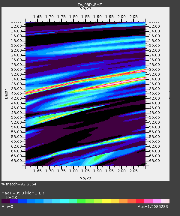
| Estimated Moho Depth: |
35.0 km |
| Estimated Crust Vp/Vs: |
2.00 |
| Assumed Crust Vp: |
6.597 km/s |
| Estimated Crust Vs: |
3.299 km/s |
| Estimated Crust Poisson's Ratio: |
0.33 |
|
| Radial Match: |
92.6354 % |
| Radial Bump: |
400 |
| Transverse Match: |
73.69403 % |
| Transverse Bump: |
400 |
| SOD ConfigId: |
7422571 |
| Insert Time: |
2019-04-19 00:44:17.256 +0000 |
| GWidth: |
2.5 |
| Max Bumps: |
400 |
| Tol: |
0.001 |
|
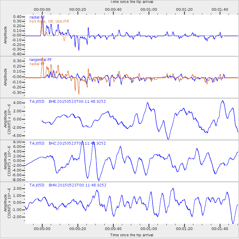
Signal To Noise
| Channel | StoN | STA | LTA |
| TA:J05D: :BHZ:20150523T00:11:48.925Z | 2.1032488 | 2.1204633E-6 | 1.0081847E-6 |
| TA:J05D: :BHN:20150523T00:11:48.925Z | 2.0588667 | 5.73885E-7 | 2.7873833E-7 |
| TA:J05D: :BHE:20150523T00:11:48.925Z | 0.8425059 | 7.6941444E-7 | 9.1324523E-7 |
| Arrivals |
| Ps | 5.4 SECOND |
| PpPs | 16 SECOND |
| PsPs/PpSs | 21 SECOND |


