You are here: Home > Network List > TA - USArray Transportable Network (new EarthScope stations) Stations List
> Station M04C Macdoel, CA, USA > Earthquake Result Viewer
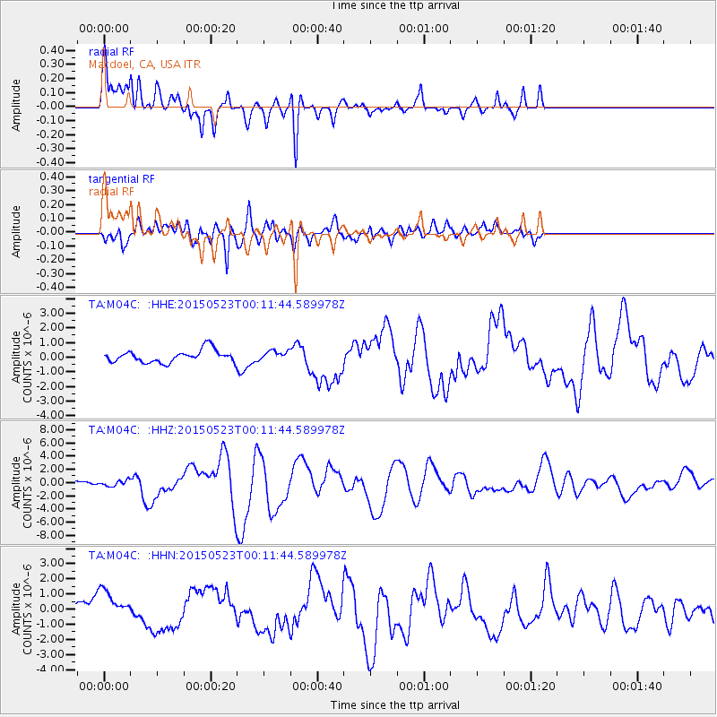
M04C Macdoel, CA, USA - Earthquake Result Viewer

| Earthquake location: |
Solomon Islands |
| Earthquake latitude/longitude: |
-11.2/163.2 |
| Earthquake time(UTC): |
2015/05/22 (142) 23:59:33 GMT |
| Earthquake Depth: |
10 km |
| Earthquake Magnitude: |
6.8 MO |
| Earthquake Catalog/Contributor: |
NEIC PDE/NEIC ALERT |
|
| Network: |
TA USArray Transportable Network (new EarthScope stations) |
| Station: |
M04C Macdoel, CA, USA |
| Lat/Lon: |
41.78 N/121.84 W |
| Elevation: |
1391 m |
|
| Distance: |
86.4 deg |
| Az: |
46.363 deg |
| Baz: |
251.738 deg |
| Ray Param: |
0.044077188 |
| Estimated Moho Depth: |
29.5 km |
| Estimated Crust Vp/Vs: |
2.10 |
| Assumed Crust Vp: |
6.566 km/s |
| Estimated Crust Vs: |
3.13 km/s |
| Estimated Crust Poisson's Ratio: |
0.35 |
|
| Radial Match: |
87.3067 % |
| Radial Bump: |
400 |
| Transverse Match: |
79.08161 % |
| Transverse Bump: |
400 |
| SOD ConfigId: |
7422571 |
| Insert Time: |
2019-04-19 00:44:20.333 +0000 |
| GWidth: |
2.5 |
| Max Bumps: |
400 |
| Tol: |
0.001 |
|
Signal To Noise
| Channel | StoN | STA | LTA |
| TA:M04C: :HHZ:20150523T00:11:44.589978Z | 1.5775048 | 4.3724316E-7 | 2.7717388E-7 |
| TA:M04C: :HHN:20150523T00:11:44.589978Z | 1.9355639 | 1.0381381E-6 | 5.3634915E-7 |
| TA:M04C: :HHE:20150523T00:11:44.589978Z | 0.78677875 | 3.4163787E-7 | 4.3422358E-7 |
| Arrivals |
| Ps | 5.0 SECOND |
| PpPs | 14 SECOND |
| PsPs/PpSs | 19 SECOND |


