You are here: Home > Network List > IU - Global Seismograph Network (GSN - IRIS/USGS) Stations List
> Station LSZ Lusaka, Zambia > Earthquake Result Viewer
LSZ Lusaka, Zambia - Earthquake Result Viewer
| Earthquake location: |
Northern Sumatra, Indonesia |
| Earthquake latitude/longitude: |
1.0/97.4 |
| Earthquake time(UTC): |
2008/01/22 (022) 17:14:57 GMT |
| Earthquake Depth: |
20 km |
| Earthquake Magnitude: |
5.9 MB, 6.2 MW, 6.1 MW |
| Earthquake Catalog/Contributor: |
WHDF/NEIC |
|
| Network: |
IU Global Seismograph Network (GSN - IRIS/USGS) |
| Station: |
LSZ Lusaka, Zambia |
| Lat/Lon: |
15.28 S/28.19 E |
| Elevation: |
1184 m |
|
| Distance: |
70.3 deg |
| Az: |
253.474 deg |
| Baz: |
83.311 deg |
| Ray Param: |
0.055059716 |
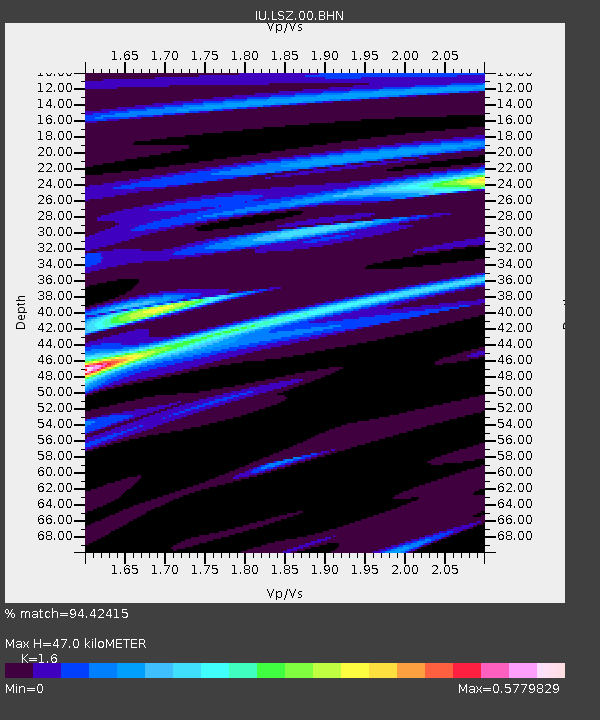
| Estimated Moho Depth: |
47.0 km |
| Estimated Crust Vp/Vs: |
1.60 |
| Assumed Crust Vp: |
6.642 km/s |
| Estimated Crust Vs: |
4.151 km/s |
| Estimated Crust Poisson's Ratio: |
0.18 |
|
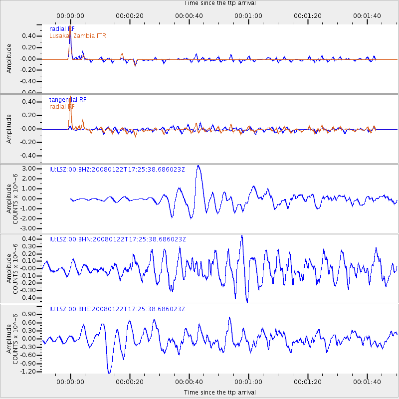
| Radial Match: |
94.42415 % |
| Radial Bump: |
335 |
| Transverse Match: |
82.66619 % |
| Transverse Bump: |
400 |
| SOD ConfigId: |
2564 |
| Insert Time: |
2010-03-02 15:25:44.080 +0000 |
| GWidth: |
2.5 |
| Max Bumps: |
400 |
| Tol: |
0.001 |
|
Signal To Noise
| Channel | StoN | STA | LTA |
| IU:LSZ:00:BHN:20080122T17:25:38.686023Z | 0.7443914 | 7.200095E-8 | 9.672459E-8 |
| IU:LSZ:00:BHE:20080122T17:25:38.686023Z | 3.4380424 | 2.2483084E-7 | 6.5395014E-8 |
| IU:LSZ:00:BHZ:20080122T17:25:38.686023Z | 6.396335 | 7.961621E-7 | 1.2447161E-7 |
| Arrivals |
| Ps | 4.4 SECOND |
| PpPs | 18 SECOND |
| PsPs/PpSs | 22 SECOND |


