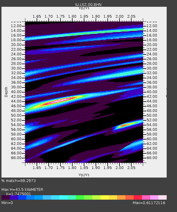
LSZ Lusaka, Zambia - Earthquake Result Viewer
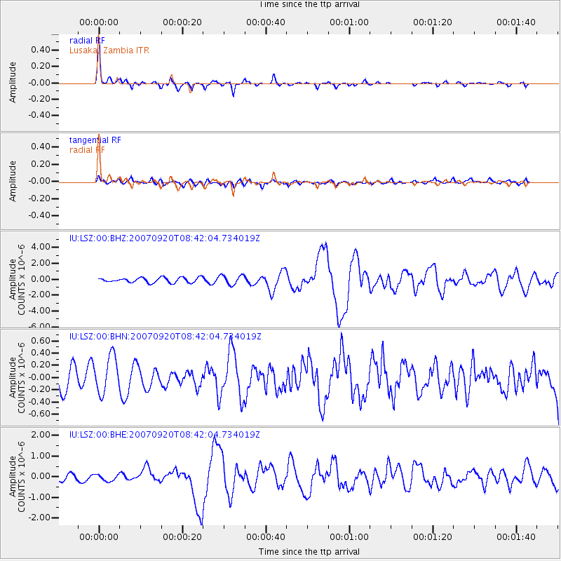
Earthquake location: Southern Sumatra, Indonesia
Earthquake latitude/longitude: -2.0/100.1
Earthquake time(UTC): 2007/09/20 (263) 08:31:14 GMT
Earthquake Depth: 30 km
Earthquake Magnitude: 6.3 MB, 6.8 MS, 6.7 MW, 6.3 ME
Earthquake Catalog/Contributor: WHDF/NEIC
Network: IU Global Seismograph Network (GSN - IRIS/USGS)
Station: LSZ Lusaka, Zambia
Lat/Lon: 15.28 S/28.19 E
Elevation: 1184 m
Distance: 72.1 deg
Az: 254.683 deg
Baz: 87.131 deg
Ray Param: 0.05386453
Estimated Moho Depth: 43.5 km
Estimated Crust Vp/Vs: 1.75
Assumed Crust Vp: 6.642 km/s
Estimated Crust Vs: 3.801 km/s
Estimated Crust Poisson's Ratio: 0.26
Radial Match: 89.2973 %
Radial Bump: 285
Transverse Match: 61.680794 %
Transverse Bump: 400
SOD ConfigId: 2564
Insert Time: 2010-03-02 15:26:05.230 +0000
GWidth: 2.5
Max Bumps: 400
Tol: 0.001

Signal To Noise

ChannelStoNSTALTA
IU:LSZ:00:BHN:20070920T08:42:04.734019Z1.30698653.110313E-72.3797591E-7
IU:LSZ:00:BHE:20070920T08:42:04.734019Z0.97918721.6352132E-71.66997E-7
IU:LSZ:00:BHZ:20070920T08:42:04.734019Z1.91328625.9439793E-73.1066858E-7
Arrivals
Ps5.1 SECOND
PpPs17 SECOND
PsPs/PpSs22 SECOND