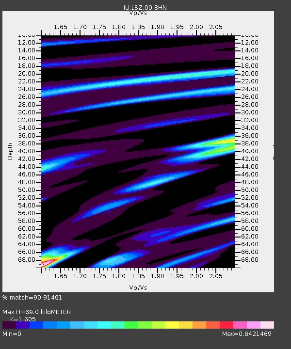
LSZ Lusaka, Zambia - Earthquake Result Viewer
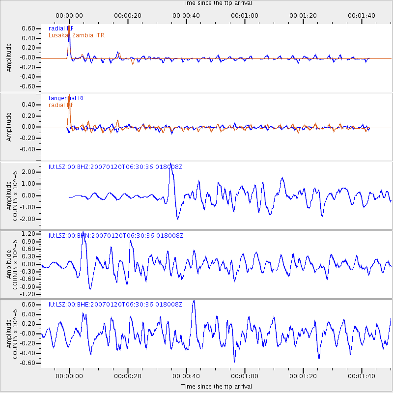
Earthquake location: South Sandwich Islands Region
Earthquake latitude/longitude: -55.4/-29.5
Earthquake time(UTC): 2007/01/20 (020) 06:21:04 GMT
Earthquake Depth: 10 km
Earthquake Magnitude: 5.7 MB, 6.2 MS, 6.2 MW, 6.1 MW
Earthquake Catalog/Contributor: WHDF/NEIC
Network: IU Global Seismograph Network (GSN - IRIS/USGS)
Station: LSZ Lusaka, Zambia
Lat/Lon: 15.28 S/28.19 E
Elevation: 1184 m
Distance: 59.4 deg
Az: 71.429 deg
Baz: 214.056 deg
Ray Param: 0.062210478
Estimated Moho Depth: 69.0 km
Estimated Crust Vp/Vs: 1.61
Assumed Crust Vp: 6.642 km/s
Estimated Crust Vs: 4.138 km/s
Estimated Crust Poisson's Ratio: 0.18
Radial Match: 90.91461 %
Radial Bump: 270
Transverse Match: 61.93876 %
Transverse Bump: 400
SOD ConfigId: 2564
Insert Time: 2010-03-02 15:26:14.294 +0000
GWidth: 2.5
Max Bumps: 400
Tol: 0.001

Signal To Noise

ChannelStoNSTALTA
IU:LSZ:00:BHN:20070120T06:30:36.018008Z4.23743634.530794E-71.06923E-7
IU:LSZ:00:BHE:20070120T06:30:36.018008Z1.44868081.7852207E-71.2323079E-7
IU:LSZ:00:BHZ:20070120T06:30:36.018008Z6.00804149.0070046E-71.4991582E-7
Arrivals
Ps6.7 SECOND
PpPs26 SECOND
PsPs/PpSs32 SECOND