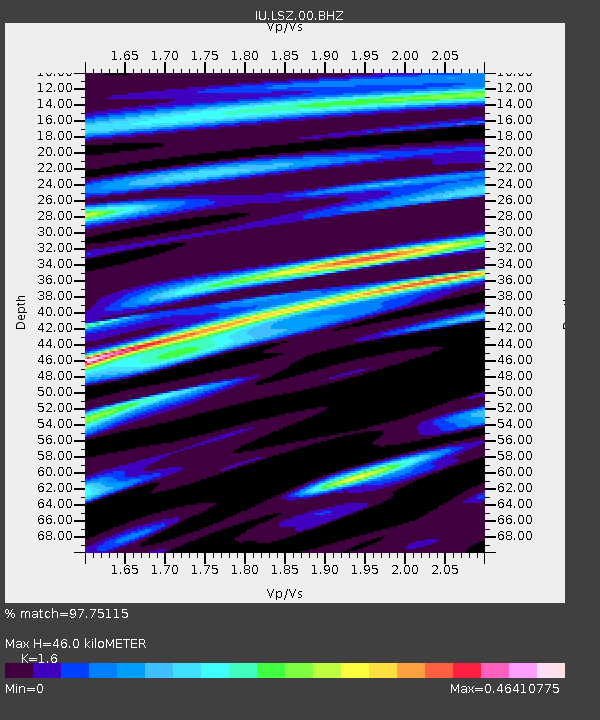
LSZ Lusaka, Zambia - Earthquake Result Viewer

Earthquake location: Minahassa Peninsula, Sulawesi
Earthquake latitude/longitude: 1.3/122.1
Earthquake time(UTC): 2008/11/16 (321) 17:02:32 GMT
Earthquake Depth: 30 km
Earthquake Magnitude: 6.5 MB, 7.0 MS, 7.3 MW, 7.3 MW
Earthquake Catalog/Contributor: WHDF/NEIC
Network: IU Global Seismograph Network (GSN - IRIS/USGS)
Station: LSZ Lusaka, Zambia
Lat/Lon: 15.28 S/28.19 E
Elevation: 1200 m
Distance: 94.1 deg
Az: 254.87 deg
Baz: 89.802 deg
Ray Param: 0.04111229
Estimated Moho Depth: 46.0 km
Estimated Crust Vp/Vs: 1.60
Assumed Crust Vp: 6.642 km/s
Estimated Crust Vs: 4.151 km/s
Estimated Crust Poisson's Ratio: 0.18
Radial Match: 97.75115 %
Radial Bump: 324
Transverse Match: 90.17987 %
Transverse Bump: 400
SOD ConfigId: 2658
Insert Time: 2010-03-02 15:26:17.587 +0000
GWidth: 2.5
Max Bumps: 400
Tol: 0.001

Signal To Noise

ChannelStoNSTALTA
IU:LSZ:00:BHZ:20081116T17:15:16.770007Z22.4181942.9579733E-61.3194521E-7
IU:LSZ:00:BHN:20081116T17:15:16.770007Z1.77384851.3007629E-77.3329986E-8
IU:LSZ:00:BHE:20081116T17:15:16.770007Z9.5218048.801285E-79.243295E-8
Arrivals
Ps4.3 SECOND
PpPs18 SECOND
PsPs/PpSs22 SECOND