LSZ Lusaka, Zambia - Earthquake Result Viewer
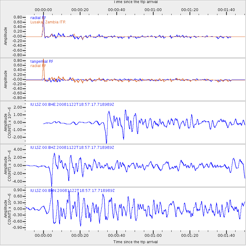
Earthquake location: North Of Ascension Island
Earthquake latitude/longitude: -1.2/-13.9
Earthquake time(UTC): 2008/11/22 (327) 18:49:42 GMT
Earthquake Depth: 10 km
Earthquake Magnitude: 5.9 MB, 6.0 MS, 6.3 MW, 6.2 MW
Earthquake Catalog/Contributor: WHDF/NEIC
Network: IU Global Seismograph Network (GSN - IRIS/USGS)
Station: LSZ Lusaka, Zambia
Lat/Lon: 15.28 S/28.19 E
Elevation: 1200 m
Distance: 43.8 deg
Az: 110.85 deg
Baz: 284.515 deg
Ray Param: 0.07229016
Estimated Moho Depth: 38.0 km
Estimated Crust Vp/Vs: 1.95
Assumed Crust Vp: 6.642 km/s
Estimated Crust Vs: 3.402 km/s
Estimated Crust Poisson's Ratio: 0.32
Radial Match: 88.12098 %
Radial Bump: 304
Transverse Match: 57.6753 %
Transverse Bump: 400
SOD ConfigId: 2658
Insert Time: 2010-03-02 15:26:21.487 +0000
GWidth: 2.5
Max Bumps: 400
Tol: 0.001

Signal To Noise

ChannelStoNSTALTA
IU:LSZ:00:BHZ:20081122T18:57:17.718989Z20.7049771.6329246E-67.8866286E-8
IU:LSZ:00:BHN:20081122T18:57:17.718989Z4.3127953.4200414E-77.929989E-8
IU:LSZ:00:BHE:20081122T18:57:17.718989Z9.1640979.1820516E-71.00195926E-7
Arrivals
Ps5.8 SECOND
PpPs16 SECOND
PsPs/PpSs22 SECOND