You are here: Home > Network List > CN - Canadian National Seismograph Network Stations List
> Station INK INUVIK, NT > Earthquake Result Viewer
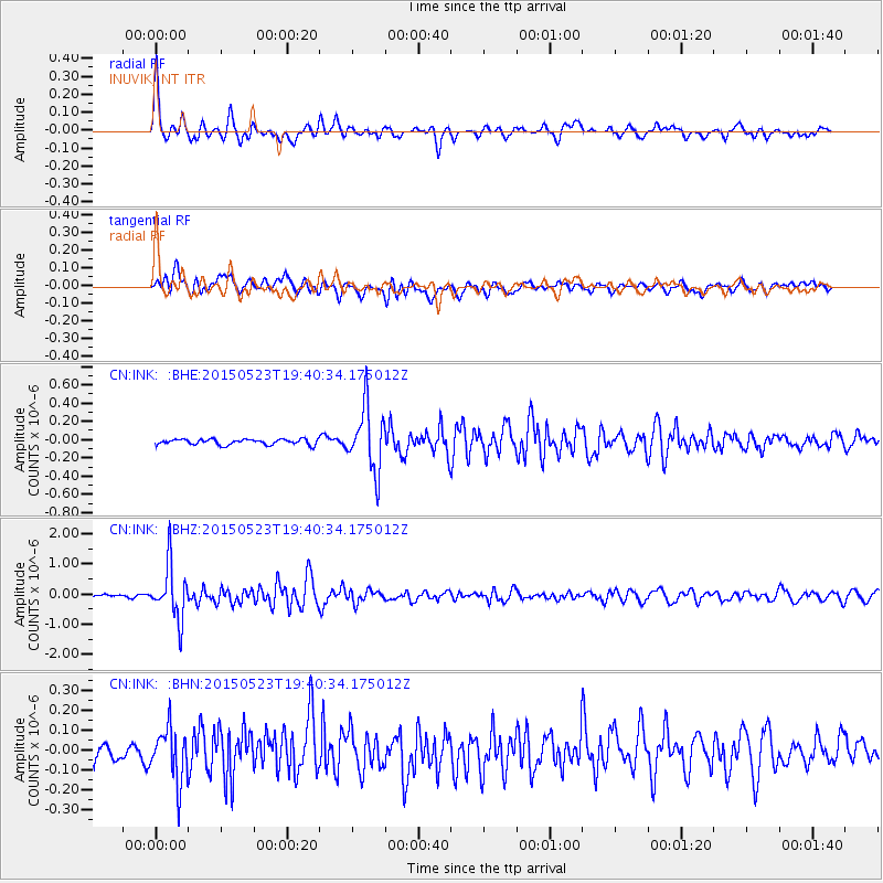
INK INUVIK, NT - Earthquake Result Viewer
*The percent match for this event was below the threshold and hence no stack was calculated.
| Earthquake location: |
New Britain Region, P.N.G. |
| Earthquake latitude/longitude: |
-4.8/152.7 |
| Earthquake time(UTC): |
2015/05/23 (143) 19:28:18 GMT |
| Earthquake Depth: |
51 km |
| Earthquake Magnitude: |
5.7 MB |
| Earthquake Catalog/Contributor: |
NEIC PDE/NEIC ALERT |
|
| Network: |
CN Canadian National Seismograph Network |
| Station: |
INK INUVIK, NT |
| Lat/Lon: |
68.31 N/133.53 W |
| Elevation: |
44 m |
|
| Distance: |
88.5 deg |
| Az: |
20.926 deg |
| Baz: |
253.193 deg |
| Ray Param: |
$rayparam |
*The percent match for this event was below the threshold and hence was not used in the summary stack. |
|
| Radial Match: |
77.50493 % |
| Radial Bump: |
350 |
| Transverse Match: |
59.645473 % |
| Transverse Bump: |
400 |
| SOD ConfigId: |
7422571 |
| Insert Time: |
2019-04-19 00:53:07.662 +0000 |
| GWidth: |
2.5 |
| Max Bumps: |
400 |
| Tol: |
0.001 |
|
Signal To Noise
| Channel | StoN | STA | LTA |
| CN:INK: :BHZ:20150523T19:40:34.175012Z | 9.850421 | 8.839698E-7 | 8.9739295E-8 |
| CN:INK: :BHN:20150523T19:40:34.175012Z | 1.7992626 | 1.3630836E-7 | 7.57579E-8 |
| CN:INK: :BHE:20150523T19:40:34.175012Z | 11.375356 | 3.4295996E-7 | 3.0149387E-8 |
| Arrivals |
| Ps | |
| PpPs | |
| PsPs/PpSs | |


