You are here: Home > Network List > CI - Caltech Regional Seismic Network Stations List
> Station OSI Osito Audit > Earthquake Result Viewer
OSI Osito Audit - Earthquake Result Viewer
| Earthquake location: |
Bonin Islands, Japan Region |
| Earthquake latitude/longitude: |
28.9/139.6 |
| Earthquake time(UTC): |
2000/08/06 (219) 07:27:12 GMT |
| Earthquake Depth: |
395 km |
| Earthquake Magnitude: |
6.3 MB, 7.3 MW, 7.3 MW |
| Earthquake Catalog/Contributor: |
WHDF/NEIC |
|
| Network: |
CI Caltech Regional Seismic Network |
| Station: |
OSI Osito Audit |
| Lat/Lon: |
34.61 N/118.72 W |
| Elevation: |
718 m |
|
| Distance: |
82.8 deg |
| Az: |
54.48 deg |
| Baz: |
300.043 deg |
| Ray Param: |
0.045540564 |
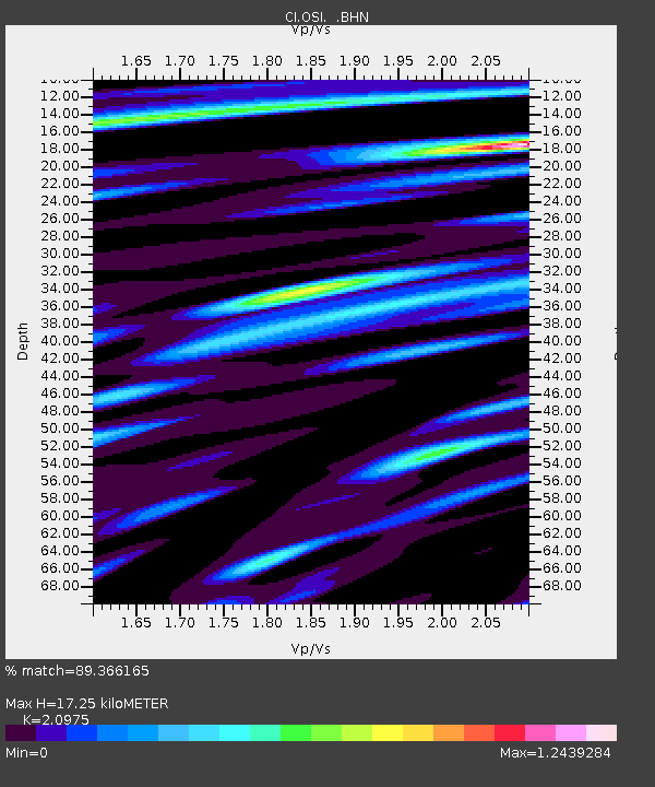
| Estimated Moho Depth: |
17.25 km |
| Estimated Crust Vp/Vs: |
2.10 |
| Assumed Crust Vp: |
6.1 km/s |
| Estimated Crust Vs: |
2.908 km/s |
| Estimated Crust Poisson's Ratio: |
0.35 |
|
| Radial Match: |
89.366165 % |
| Radial Bump: |
400 |
| Transverse Match: |
78.065544 % |
| Transverse Bump: |
400 |
| SOD ConfigId: |
3753 |
| Insert Time: |
2010-02-25 21:25:10.548 +0000 |
| GWidth: |
2.5 |
| Max Bumps: |
400 |
| Tol: |
0.001 |
|

Signal To Noise
| Channel | StoN | STA | LTA |
| CI:OSI: :BHN:20000806T07:38:23.16001Z | 2.4899697 | 4.4262765E-7 | 1.7776428E-7 |
| CI:OSI: :BHE:20000806T07:38:23.16001Z | 4.049916 | 6.754898E-7 | 1.6679107E-7 |
| CI:OSI: :BHZ:20000806T07:38:23.16001Z | 8.550945 | 2.2830106E-6 | 2.6698928E-7 |
| Arrivals |
| Ps | 3.2 SECOND |
| PpPs | 8.6 SECOND |
| PsPs/PpSs | 12 SECOND |


