You are here: Home > Network List > TA - USArray Transportable Network (new EarthScope stations) Stations List
> Station L04D Klamath Falls, OR, USA > Earthquake Result Viewer
L04D Klamath Falls, OR, USA - Earthquake Result Viewer
*The percent match for this event was below the threshold and hence no stack was calculated.
| Earthquake location: |
New Britain Region, P.N.G. |
| Earthquake latitude/longitude: |
-4.8/152.7 |
| Earthquake time(UTC): |
2015/05/23 (143) 19:28:18 GMT |
| Earthquake Depth: |
51 km |
| Earthquake Magnitude: |
5.7 MB |
| Earthquake Catalog/Contributor: |
NEIC PDE/NEIC ALERT |
|
| Network: |
TA USArray Transportable Network (new EarthScope stations) |
| Station: |
L04D Klamath Falls, OR, USA |
| Lat/Lon: |
42.22 N/122.30 W |
| Elevation: |
1437 m |
|
| Distance: |
89.5 deg |
| Az: |
47.737 deg |
| Baz: |
263.106 deg |
| Ray Param: |
$rayparam |
*The percent match for this event was below the threshold and hence was not used in the summary stack. |
|
| Radial Match: |
59.080204 % |
| Radial Bump: |
400 |
| Transverse Match: |
64.78312 % |
| Transverse Bump: |
380 |
| SOD ConfigId: |
7422571 |
| Insert Time: |
2019-04-19 00:55:47.487 +0000 |
| GWidth: |
2.5 |
| Max Bumps: |
400 |
| Tol: |
0.001 |
|
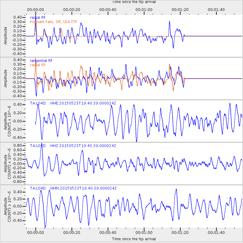
Signal To Noise
| Channel | StoN | STA | LTA |
| TA:L04D: :HHZ:20150523T19:40:39.000024Z | 2.6703458 | 3.8183896E-7 | 1.4299233E-7 |
| TA:L04D: :HHN:20150523T19:40:39.000024Z | 1.5734732 | 2.758813E-7 | 1.7533269E-7 |
| TA:L04D: :HHE:20150523T19:40:39.000024Z | 0.6726916 | 1.1957037E-7 | 1.7774917E-7 |
| Arrivals |
| Ps | |
| PpPs | |
| PsPs/PpSs | |


