You are here: Home > Network List > IU - Global Seismograph Network (GSN - IRIS/USGS) Stations List
> Station LSZ Lusaka, Zambia > Earthquake Result Viewer
LSZ Lusaka, Zambia - Earthquake Result Viewer
| Earthquake location: |
Flores Sea |
| Earthquake latitude/longitude: |
-7.8/122.6 |
| Earthquake time(UTC): |
2006/01/15 (015) 11:58:29 GMT |
| Earthquake Depth: |
265 km |
| Earthquake Magnitude: |
6.0 MB, 6.1 MW, 6.1 MW |
| Earthquake Catalog/Contributor: |
WHDF/NEIC |
|
| Network: |
IU Global Seismograph Network (GSN - IRIS/USGS) |
| Station: |
LSZ Lusaka, Zambia |
| Lat/Lon: |
15.28 S/28.19 E |
| Elevation: |
1184 m |
|
| Distance: |
92.2 deg |
| Az: |
254.356 deg |
| Baz: |
98.662 deg |
| Ray Param: |
0.041342326 |
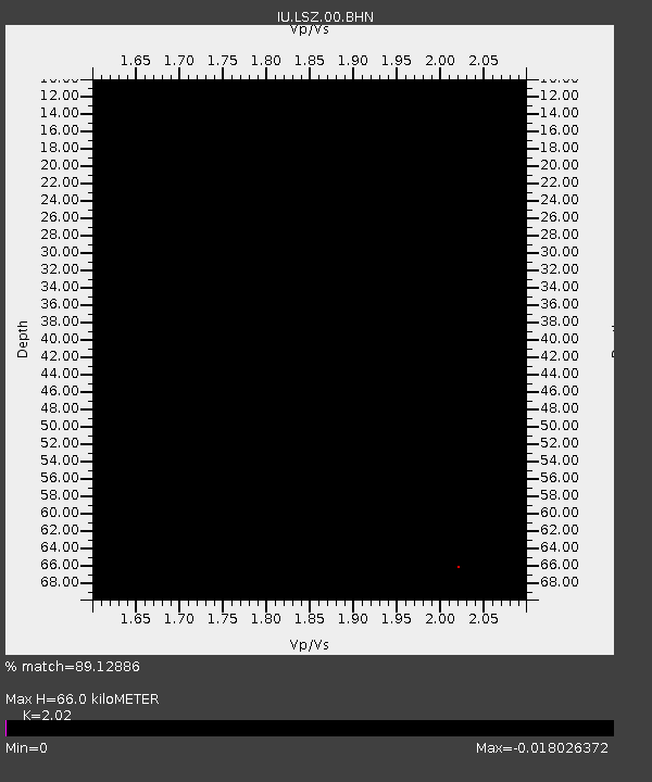
| Estimated Moho Depth: |
66.0 km |
| Estimated Crust Vp/Vs: |
2.02 |
| Assumed Crust Vp: |
6.642 km/s |
| Estimated Crust Vs: |
3.288 km/s |
| Estimated Crust Poisson's Ratio: |
0.34 |
|
| Radial Match: |
89.12886 % |
| Radial Bump: |
287 |
| Transverse Match: |
42.97392 % |
| Transverse Bump: |
400 |
| SOD ConfigId: |
2669 |
| Insert Time: |
2010-03-02 15:27:13.152 +0000 |
| GWidth: |
2.5 |
| Max Bumps: |
400 |
| Tol: |
0.001 |
|
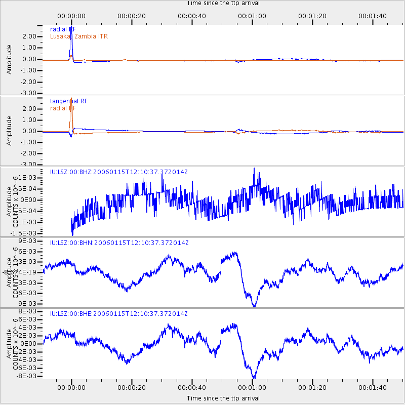
Signal To Noise
| Channel | StoN | STA | LTA |
| IU:LSZ:00:BHN:20060115T12:10:37.372014Z | 1.1491344 | 3.3270517E-9 | 2.8952676E-9 |
| IU:LSZ:00:BHE:20060115T12:10:37.372014Z | 1.2568372 | 2.679952E-9 | 2.1322983E-9 |
| IU:LSZ:00:BHZ:20060115T12:10:37.372014Z | 1.1461341 | 6.0900024E-10 | 5.3135163E-10 |
| Arrivals |
| Ps | 10 SECOND |
| PpPs | 29 SECOND |
| PsPs/PpSs | 40 SECOND |


