You are here: Home > Network List > IU - Global Seismograph Network (GSN - IRIS/USGS) Stations List
> Station LSZ Lusaka, Zambia > Earthquake Result Viewer
LSZ Lusaka, Zambia - Earthquake Result Viewer
| Earthquake location: |
Andaman Islands, India Region |
| Earthquake latitude/longitude: |
12.2/95.2 |
| Earthquake time(UTC): |
2006/01/06 (006) 04:25:05 GMT |
| Earthquake Depth: |
25 km |
| Earthquake Magnitude: |
5.5 MB, 4.8 MS, 5.3 MW |
| Earthquake Catalog/Contributor: |
WHDF/NEIC |
|
| Network: |
IU Global Seismograph Network (GSN - IRIS/USGS) |
| Station: |
LSZ Lusaka, Zambia |
| Lat/Lon: |
15.28 S/28.19 E |
| Elevation: |
1184 m |
|
| Distance: |
71.7 deg |
| Az: |
249.322 deg |
| Baz: |
71.382 deg |
| Ray Param: |
0.054094963 |
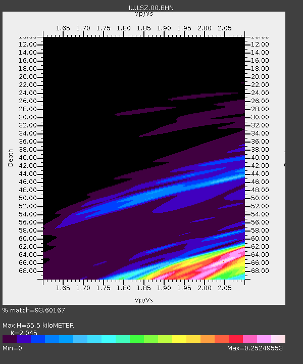
| Estimated Moho Depth: |
65.5 km |
| Estimated Crust Vp/Vs: |
2.05 |
| Assumed Crust Vp: |
6.642 km/s |
| Estimated Crust Vs: |
3.248 km/s |
| Estimated Crust Poisson's Ratio: |
0.34 |
|
| Radial Match: |
93.60167 % |
| Radial Bump: |
180 |
| Transverse Match: |
94.889915 % |
| Transverse Bump: |
158 |
| SOD ConfigId: |
2669 |
| Insert Time: |
2010-03-02 15:27:15.316 +0000 |
| GWidth: |
2.5 |
| Max Bumps: |
400 |
| Tol: |
0.001 |
|
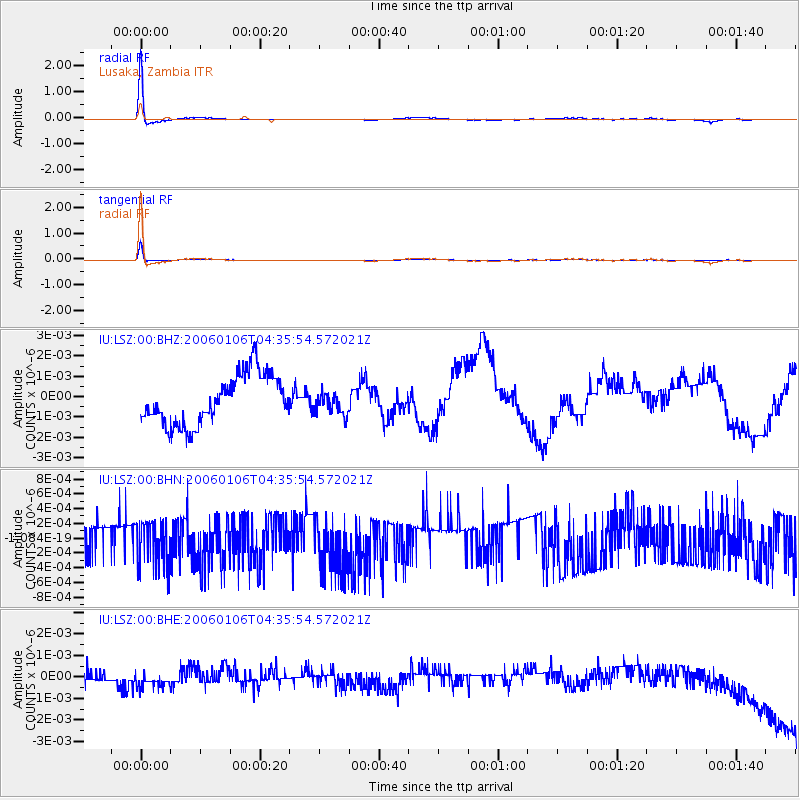
Signal To Noise
| Channel | StoN | STA | LTA |
| IU:LSZ:00:BHN:20060106T04:35:54.572021Z | 1.2116556 | 3.1073202E-10 | 2.5645244E-10 |
| IU:LSZ:00:BHE:20060106T04:35:54.572021Z | 1.2460644 | 4.4061985E-10 | 3.536092E-10 |
| IU:LSZ:00:BHZ:20060106T04:35:54.572021Z | 0.45114014 | 5.389662E-10 | 1.1946758E-9 |
| Arrivals |
| Ps | 11 SECOND |
| PpPs | 29 SECOND |
| PsPs/PpSs | 40 SECOND |


