You are here: Home > Network List > UW - Pacific Northwest Regional Seismic Network Stations List
> Station UMAT Pilot Rock, OR, USA > Earthquake Result Viewer
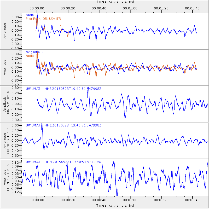
UMAT Pilot Rock, OR, USA - Earthquake Result Viewer
*The percent match for this event was below the threshold and hence no stack was calculated.
| Earthquake location: |
New Britain Region, P.N.G. |
| Earthquake latitude/longitude: |
-4.8/152.7 |
| Earthquake time(UTC): |
2015/05/23 (143) 19:28:18 GMT |
| Earthquake Depth: |
51 km |
| Earthquake Magnitude: |
5.7 MB |
| Earthquake Catalog/Contributor: |
NEIC PDE/NEIC ALERT |
|
| Network: |
UW Pacific Northwest Regional Seismic Network |
| Station: |
UMAT Pilot Rock, OR, USA |
| Lat/Lon: |
45.29 N/118.96 W |
| Elevation: |
1318 m |
|
| Distance: |
92.3 deg |
| Az: |
44.924 deg |
| Baz: |
265.457 deg |
| Ray Param: |
$rayparam |
*The percent match for this event was below the threshold and hence was not used in the summary stack. |
|
| Radial Match: |
63.709286 % |
| Radial Bump: |
301 |
| Transverse Match: |
68.32834 % |
| Transverse Bump: |
399 |
| SOD ConfigId: |
7422571 |
| Insert Time: |
2019-04-19 00:56:50.674 +0000 |
| GWidth: |
2.5 |
| Max Bumps: |
400 |
| Tol: |
0.001 |
|
Signal To Noise
| Channel | StoN | STA | LTA |
| UW:UMAT: :HHZ:20150523T19:40:51.547998Z | 3.9683778 | 2.6881517E-7 | 6.773931E-8 |
| UW:UMAT: :HHN:20150523T19:40:51.547998Z | 0.9740026 | 5.8224103E-8 | 5.977818E-8 |
| UW:UMAT: :HHE:20150523T19:40:51.547998Z | 2.04484 | 1.4854716E-7 | 7.264487E-8 |
| Arrivals |
| Ps | |
| PpPs | |
| PsPs/PpSs | |


