You are here: Home > Network List > JP - Japan Meteorological Agency Seismic Network Stations List
> Station JWT Kyoto Wachi > Earthquake Result Viewer
JWT Kyoto Wachi - Earthquake Result Viewer
| Earthquake location: |
Banda Sea |
| Earthquake latitude/longitude: |
-5.4/131.2 |
| Earthquake time(UTC): |
2015/05/23 (143) 19:40:47 GMT |
| Earthquake Depth: |
35 km |
| Earthquake Magnitude: |
5.0 mb, 5.0 mb |
| Earthquake Catalog/Contributor: |
ISC/ISC |
|
| Network: |
JP Japan Meteorological Agency Seismic Network |
| Station: |
JWT Kyoto Wachi |
| Lat/Lon: |
35.29 N/135.40 E |
| Elevation: |
172 m |
|
| Distance: |
40.7 deg |
| Az: |
5.213 deg |
| Baz: |
186.348 deg |
| Ray Param: |
0.07417747 |
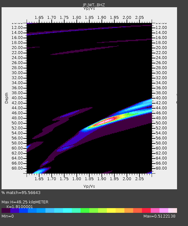
| Estimated Moho Depth: |
49.25 km |
| Estimated Crust Vp/Vs: |
1.91 |
| Assumed Crust Vp: |
6.468 km/s |
| Estimated Crust Vs: |
3.386 km/s |
| Estimated Crust Poisson's Ratio: |
0.31 |
|
| Radial Match: |
95.56643 % |
| Radial Bump: |
400 |
| Transverse Match: |
88.49917 % |
| Transverse Bump: |
400 |
| SOD ConfigId: |
7422571 |
| Insert Time: |
2019-04-19 00:59:57.749 +0000 |
| GWidth: |
2.5 |
| Max Bumps: |
400 |
| Tol: |
0.001 |
|

Signal To Noise
| Channel | StoN | STA | LTA |
| JP:JWT: :BHZ:20150523T19:47:54.200011Z | 1.8950691 | 3.019495E-7 | 1.593343E-7 |
| JP:JWT: :BHN:20150523T19:47:54.200011Z | 1.6548252 | 2.7314323E-7 | 1.6505867E-7 |
| JP:JWT: :BHE:20150523T19:47:54.200011Z | 1.172833 | 2.3061868E-7 | 1.9663388E-7 |
| Arrivals |
| Ps | 7.4 SECOND |
| PpPs | 21 SECOND |
| PsPs/PpSs | 28 SECOND |


