You are here: Home > Network List > IC - New China Digital Seismograph Network Stations List
> Station KMI Kunming, Yunnan Province, China > Earthquake Result Viewer
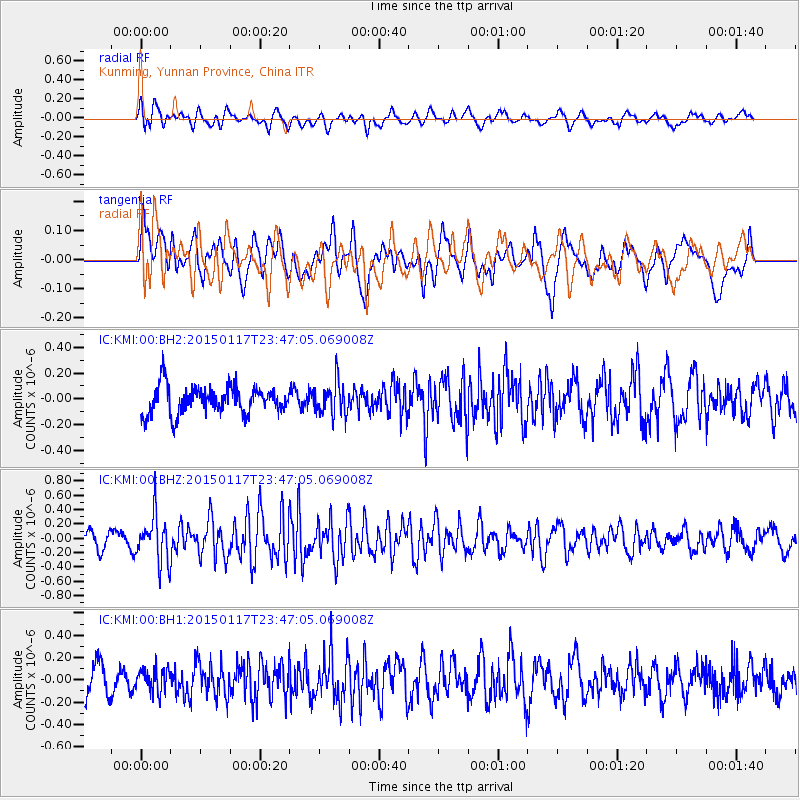
KMI Kunming, Yunnan Province, China - Earthquake Result Viewer
*The percent match for this event was below the threshold and hence no stack was calculated.
| Earthquake location: |
Banda Sea |
| Earthquake latitude/longitude: |
-5.8/131.8 |
| Earthquake time(UTC): |
2015/01/17 (017) 23:39:52 GMT |
| Earthquake Depth: |
63 km |
| Earthquake Magnitude: |
5.6 MB |
| Earthquake Catalog/Contributor: |
NEIC PDE/NEIC COMCAT |
|
| Network: |
IC New China Digital Seismograph Network |
| Station: |
KMI Kunming, Yunnan Province, China |
| Lat/Lon: |
25.12 N/102.74 E |
| Elevation: |
1975 m |
|
| Distance: |
41.8 deg |
| Az: |
318.548 deg |
| Baz: |
133.395 deg |
| Ray Param: |
$rayparam |
*The percent match for this event was below the threshold and hence was not used in the summary stack. |
|
| Radial Match: |
57.491062 % |
| Radial Bump: |
400 |
| Transverse Match: |
50.74816 % |
| Transverse Bump: |
400 |
| SOD ConfigId: |
837871 |
| Insert Time: |
2015-01-31 23:57:58.796 +0000 |
| GWidth: |
2.5 |
| Max Bumps: |
400 |
| Tol: |
0.001 |
|
Signal To Noise
| Channel | StoN | STA | LTA |
| IC:KMI:00:BHZ:20150117T23:47:05.069008Z | 3.060415 | 3.2635324E-7 | 1.06636925E-7 |
| IC:KMI:00:BH1:20150117T23:47:05.069008Z | 0.7407446 | 1.0342981E-7 | 1.3962952E-7 |
| IC:KMI:00:BH2:20150117T23:47:05.069008Z | 1.1786158 | 1.2708595E-7 | 1.07826445E-7 |
| Arrivals |
| Ps | |
| PpPs | |
| PsPs/PpSs | |


