You are here: Home > Network List > 7A - Mid-Atlantic Geophysical Integrative Collaboration Stations List
> Station FOXP Brandywine, West Virginia USA > Earthquake Result Viewer
FOXP Brandywine, West Virginia USA - Earthquake Result Viewer
| Earthquake location: |
Southern Mid-Atlantic Ridge |
| Earthquake latitude/longitude: |
-16.8/-14.2 |
| Earthquake time(UTC): |
2015/05/24 (144) 04:53:22 GMT |
| Earthquake Depth: |
10 km |
| Earthquake Magnitude: |
6.3 MWP |
| Earthquake Catalog/Contributor: |
NEIC PDE/NEIC COMCAT |
|
| Network: |
7A Mid-Atlantic Geophysical Integrative Collaboration |
| Station: |
FOXP Brandywine, West Virginia USA |
| Lat/Lon: |
38.63 N/79.25 W |
| Elevation: |
485 m |
|
| Distance: |
82.1 deg |
| Az: |
314.191 deg |
| Baz: |
118.752 deg |
| Ray Param: |
0.047120523 |
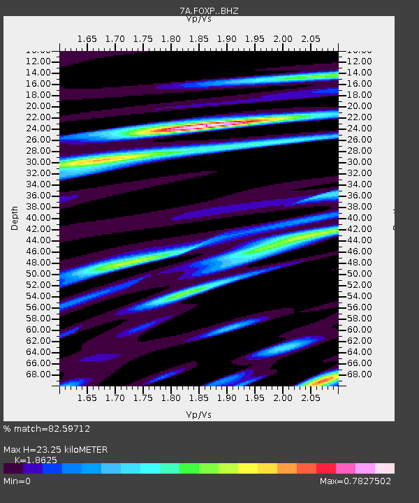
| Estimated Moho Depth: |
23.25 km |
| Estimated Crust Vp/Vs: |
1.86 |
| Assumed Crust Vp: |
6.159 km/s |
| Estimated Crust Vs: |
3.307 km/s |
| Estimated Crust Poisson's Ratio: |
0.30 |
|
| Radial Match: |
82.59712 % |
| Radial Bump: |
400 |
| Transverse Match: |
67.07088 % |
| Transverse Bump: |
400 |
| SOD ConfigId: |
7422571 |
| Insert Time: |
2019-04-19 01:01:38.836 +0000 |
| GWidth: |
2.5 |
| Max Bumps: |
400 |
| Tol: |
0.001 |
|

Signal To Noise
| Channel | StoN | STA | LTA |
| 7A:FOXP: :BHZ:20150524T05:05:11.955022Z | 3.2188694 | 4.741084E-7 | 1.4729035E-7 |
| 7A:FOXP: :BHN:20150524T05:05:11.955022Z | 0.68941844 | 1.448237E-7 | 2.1006649E-7 |
| 7A:FOXP: :BHE:20150524T05:05:11.955022Z | 1.1159806 | 1.5336535E-7 | 1.3742654E-7 |
| Arrivals |
| Ps | 3.3 SECOND |
| PpPs | 11 SECOND |
| PsPs/PpSs | 14 SECOND |


