You are here: Home > Network List > BE - Belgian Seismic Network Stations List
> Station RCHB Rochefort, Belgium > Earthquake Result Viewer
RCHB Rochefort, Belgium - Earthquake Result Viewer
| Earthquake location: |
Southern Mid-Atlantic Ridge |
| Earthquake latitude/longitude: |
-16.8/-14.2 |
| Earthquake time(UTC): |
2015/05/24 (144) 04:53:22 GMT |
| Earthquake Depth: |
10 km |
| Earthquake Magnitude: |
6.3 MWP |
| Earthquake Catalog/Contributor: |
NEIC PDE/NEIC COMCAT |
|
| Network: |
BE Belgian Seismic Network |
| Station: |
RCHB Rochefort, Belgium |
| Lat/Lon: |
50.16 N/5.23 E |
| Elevation: |
191 m |
|
| Distance: |
68.9 deg |
| Az: |
13.252 deg |
| Baz: |
199.956 deg |
| Ray Param: |
0.05602889 |
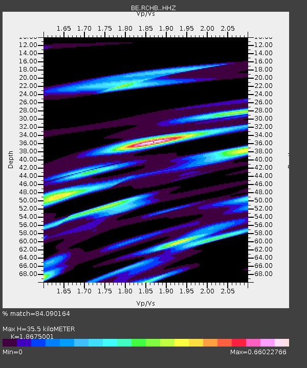
| Estimated Moho Depth: |
35.5 km |
| Estimated Crust Vp/Vs: |
1.87 |
| Assumed Crust Vp: |
6.276 km/s |
| Estimated Crust Vs: |
3.361 km/s |
| Estimated Crust Poisson's Ratio: |
0.30 |
|
| Radial Match: |
84.090164 % |
| Radial Bump: |
400 |
| Transverse Match: |
75.98552 % |
| Transverse Bump: |
400 |
| SOD ConfigId: |
7422571 |
| Insert Time: |
2019-04-19 01:02:05.222 +0000 |
| GWidth: |
2.5 |
| Max Bumps: |
400 |
| Tol: |
0.001 |
|

Signal To Noise
| Channel | StoN | STA | LTA |
| BE:RCHB: :HHZ:20150524T05:03:56.52802Z | 2.2023728 | 7.4097403E-7 | 3.3644352E-7 |
| BE:RCHB: :HHN:20150524T05:03:56.52802Z | 2.944601 | 2.4155545E-7 | 8.203334E-8 |
| BE:RCHB: :HHE:20150524T05:03:56.52802Z | 3.024644 | 2.1292615E-7 | 7.03971E-8 |
| Arrivals |
| Ps | 5.1 SECOND |
| PpPs | 16 SECOND |
| PsPs/PpSs | 21 SECOND |


