You are here: Home > Network List > GB - Great Britain Seismograph Network Stations List
> Station CCA1 CARNMENELLIS, ENGLAND > Earthquake Result Viewer
CCA1 CARNMENELLIS, ENGLAND - Earthquake Result Viewer
| Earthquake location: |
Southern Mid-Atlantic Ridge |
| Earthquake latitude/longitude: |
-16.8/-14.2 |
| Earthquake time(UTC): |
2015/05/24 (144) 04:53:22 GMT |
| Earthquake Depth: |
10 km |
| Earthquake Magnitude: |
6.3 MWP |
| Earthquake Catalog/Contributor: |
NEIC PDE/NEIC COMCAT |
|
| Network: |
GB Great Britain Seismograph Network |
| Station: |
CCA1 CARNMENELLIS, ENGLAND |
| Lat/Lon: |
50.19 N/5.23 W |
| Elevation: |
209 m |
|
| Distance: |
67.2 deg |
| Az: |
6.234 deg |
| Baz: |
189.311 deg |
| Ray Param: |
0.057119027 |
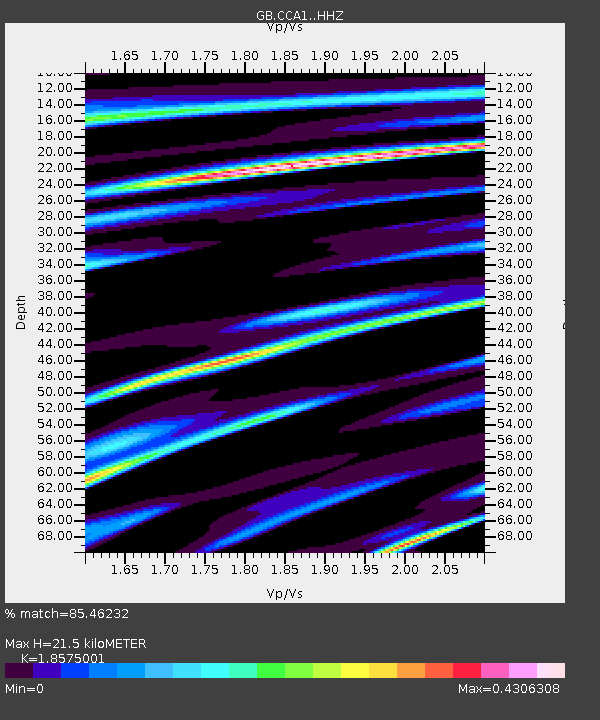
| Estimated Moho Depth: |
21.5 km |
| Estimated Crust Vp/Vs: |
1.86 |
| Assumed Crust Vp: |
6.24 km/s |
| Estimated Crust Vs: |
3.359 km/s |
| Estimated Crust Poisson's Ratio: |
0.30 |
|
| Radial Match: |
85.46232 % |
| Radial Bump: |
395 |
| Transverse Match: |
62.178757 % |
| Transverse Bump: |
400 |
| SOD ConfigId: |
7422571 |
| Insert Time: |
2019-04-19 01:03:06.226 +0000 |
| GWidth: |
2.5 |
| Max Bumps: |
400 |
| Tol: |
0.001 |
|

Signal To Noise
| Channel | StoN | STA | LTA |
| GB:CCA1: :HHZ:20150524T05:03:46.000005Z | 2.0288038 | 4.6369792E-7 | 2.285573E-7 |
| GB:CCA1: :HHN:20150524T05:03:46.000005Z | 1.3326875 | 2.5394513E-7 | 1.9055113E-7 |
| GB:CCA1: :HHE:20150524T05:03:46.000005Z | 0.6556407 | 8.882875E-8 | 1.3548389E-7 |
| Arrivals |
| Ps | 3.1 SECOND |
| PpPs | 9.5 SECOND |
| PsPs/PpSs | 13 SECOND |


