You are here: Home > Network List > N4 - Central and EAstern US Network Stations List
> Station 152A Waverly Hall, GA, USA > Earthquake Result Viewer
152A Waverly Hall, GA, USA - Earthquake Result Viewer
| Earthquake location: |
Southern Mid-Atlantic Ridge |
| Earthquake latitude/longitude: |
-16.8/-14.2 |
| Earthquake time(UTC): |
2015/05/24 (144) 04:53:22 GMT |
| Earthquake Depth: |
10 km |
| Earthquake Magnitude: |
6.3 MWP |
| Earthquake Catalog/Contributor: |
NEIC PDE/NEIC COMCAT |
|
| Network: |
N4 Central and EAstern US Network |
| Station: |
152A Waverly Hall, GA, USA |
| Lat/Lon: |
32.67 N/84.72 W |
| Elevation: |
214 m |
|
| Distance: |
83.4 deg |
| Az: |
306.821 deg |
| Baz: |
114.64 deg |
| Ray Param: |
0.046202283 |
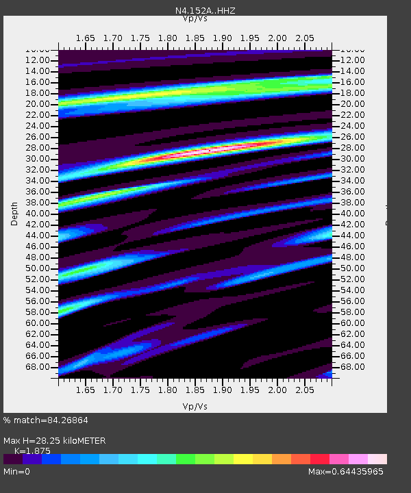
| Estimated Moho Depth: |
28.25 km |
| Estimated Crust Vp/Vs: |
1.88 |
| Assumed Crust Vp: |
6.719 km/s |
| Estimated Crust Vs: |
3.584 km/s |
| Estimated Crust Poisson's Ratio: |
0.30 |
|
| Radial Match: |
84.26864 % |
| Radial Bump: |
400 |
| Transverse Match: |
56.655014 % |
| Transverse Bump: |
400 |
| SOD ConfigId: |
7422571 |
| Insert Time: |
2019-04-19 01:04:37.301 +0000 |
| GWidth: |
2.5 |
| Max Bumps: |
400 |
| Tol: |
0.001 |
|

Signal To Noise
| Channel | StoN | STA | LTA |
| N4:152A: :HHZ:20150524T05:05:18.760015Z | 4.202858 | 3.906361E-7 | 9.294535E-8 |
| N4:152A: :HHN:20150524T05:05:18.760015Z | 1.2561336 | 1.0526748E-7 | 8.3802774E-8 |
| N4:152A: :HHE:20150524T05:05:18.760015Z | 1.6413877 | 1.4366857E-7 | 8.752872E-8 |
| Arrivals |
| Ps | 3.8 SECOND |
| PpPs | 12 SECOND |
| PsPs/PpSs | 16 SECOND |


