You are here: Home > Network List > TA - USArray Transportable Network (new EarthScope stations) Stations List
> Station G57A Newington, ON, CAN > Earthquake Result Viewer
G57A Newington, ON, CAN - Earthquake Result Viewer
| Earthquake location: |
Southern Mid-Atlantic Ridge |
| Earthquake latitude/longitude: |
-16.8/-14.2 |
| Earthquake time(UTC): |
2015/05/24 (144) 04:53:22 GMT |
| Earthquake Depth: |
10 km |
| Earthquake Magnitude: |
6.3 MWP |
| Earthquake Catalog/Contributor: |
NEIC PDE/NEIC COMCAT |
|
| Network: |
TA USArray Transportable Network (new EarthScope stations) |
| Station: |
G57A Newington, ON, CAN |
| Lat/Lon: |
45.10 N/74.99 W |
| Elevation: |
96 m |
|
| Distance: |
82.7 deg |
| Az: |
321.442 deg |
| Baz: |
122.552 deg |
| Ray Param: |
0.046732236 |
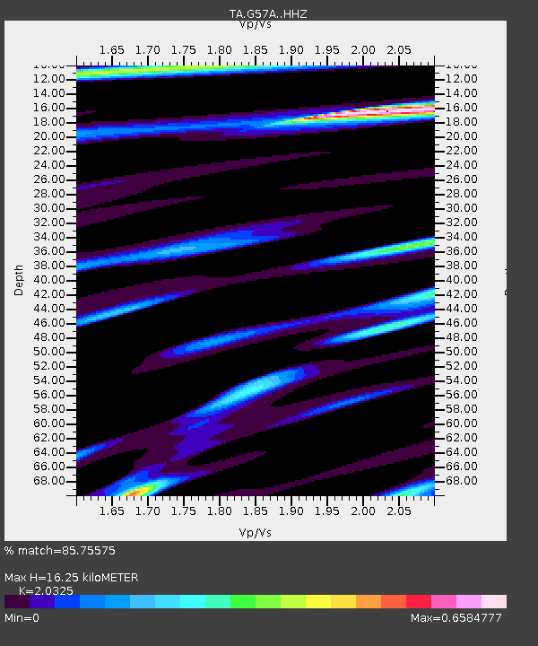
| Estimated Moho Depth: |
16.25 km |
| Estimated Crust Vp/Vs: |
2.03 |
| Assumed Crust Vp: |
6.419 km/s |
| Estimated Crust Vs: |
3.158 km/s |
| Estimated Crust Poisson's Ratio: |
0.34 |
|
| Radial Match: |
85.75575 % |
| Radial Bump: |
400 |
| Transverse Match: |
64.36287 % |
| Transverse Bump: |
400 |
| SOD ConfigId: |
7422571 |
| Insert Time: |
2019-04-19 01:07:41.273 +0000 |
| GWidth: |
2.5 |
| Max Bumps: |
400 |
| Tol: |
0.001 |
|
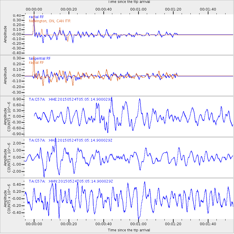
Signal To Noise
| Channel | StoN | STA | LTA |
| TA:G57A: :HHZ:20150524T05:05:14.900029Z | 1.6572214 | 5.40821E-7 | 3.2634202E-7 |
| TA:G57A: :HHN:20150524T05:05:14.900029Z | 0.8698835 | 1.2596551E-7 | 1.4480733E-7 |
| TA:G57A: :HHE:20150524T05:05:14.900029Z | 0.9791406 | 1.9831525E-7 | 2.0254012E-7 |
| Arrivals |
| Ps | 2.7 SECOND |
| PpPs | 7.5 SECOND |
| PsPs/PpSs | 10 SECOND |


