You are here: Home > Network List > TA - USArray Transportable Network (new EarthScope stations) Stations List
> Station K63A Dunstable, MA, USA > Earthquake Result Viewer
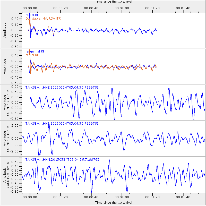
K63A Dunstable, MA, USA - Earthquake Result Viewer
*The percent match for this event was below the threshold and hence no stack was calculated.
| Earthquake location: |
Southern Mid-Atlantic Ridge |
| Earthquake latitude/longitude: |
-16.8/-14.2 |
| Earthquake time(UTC): |
2015/05/24 (144) 04:53:22 GMT |
| Earthquake Depth: |
10 km |
| Earthquake Magnitude: |
6.3 MWP |
| Earthquake Catalog/Contributor: |
NEIC PDE/NEIC COMCAT |
|
| Network: |
TA USArray Transportable Network (new EarthScope stations) |
| Station: |
K63A Dunstable, MA, USA |
| Lat/Lon: |
42.69 N/71.53 W |
| Elevation: |
68 m |
|
| Distance: |
79.2 deg |
| Az: |
320.813 deg |
| Baz: |
124.843 deg |
| Ray Param: |
$rayparam |
*The percent match for this event was below the threshold and hence was not used in the summary stack. |
|
| Radial Match: |
76.68182 % |
| Radial Bump: |
400 |
| Transverse Match: |
65.93673 % |
| Transverse Bump: |
400 |
| SOD ConfigId: |
7422571 |
| Insert Time: |
2019-04-19 01:08:03.569 +0000 |
| GWidth: |
2.5 |
| Max Bumps: |
400 |
| Tol: |
0.001 |
|
Signal To Noise
| Channel | StoN | STA | LTA |
| TA:K63A: :HHZ:20150524T05:04:56.719976Z | 2.9579947 | 6.6908575E-7 | 2.2619572E-7 |
| TA:K63A: :HHN:20150524T05:04:56.719976Z | 1.7078285 | 2.953607E-7 | 1.7294518E-7 |
| TA:K63A: :HHE:20150524T05:04:56.719976Z | 2.5146 | 4.8460026E-7 | 1.9271465E-7 |
| Arrivals |
| Ps | |
| PpPs | |
| PsPs/PpSs | |


