You are here: Home > Network List > TA - USArray Transportable Network (new EarthScope stations) Stations List
> Station L59A Walton, NY, USA > Earthquake Result Viewer
L59A Walton, NY, USA - Earthquake Result Viewer
*The percent match for this event was below the threshold and hence no stack was calculated.
| Earthquake location: |
Southern Mid-Atlantic Ridge |
| Earthquake latitude/longitude: |
-16.8/-14.2 |
| Earthquake time(UTC): |
2015/05/24 (144) 04:53:22 GMT |
| Earthquake Depth: |
10 km |
| Earthquake Magnitude: |
6.3 MWP |
| Earthquake Catalog/Contributor: |
NEIC PDE/NEIC COMCAT |
|
| Network: |
TA USArray Transportable Network (new EarthScope stations) |
| Station: |
L59A Walton, NY, USA |
| Lat/Lon: |
42.19 N/75.04 W |
| Elevation: |
677 m |
|
| Distance: |
81.1 deg |
| Az: |
318.934 deg |
| Baz: |
122.159 deg |
| Ray Param: |
$rayparam |
*The percent match for this event was below the threshold and hence was not used in the summary stack. |
|
| Radial Match: |
77.42059 % |
| Radial Bump: |
377 |
| Transverse Match: |
79.35773 % |
| Transverse Bump: |
400 |
| SOD ConfigId: |
7422571 |
| Insert Time: |
2019-04-19 01:08:03.585 +0000 |
| GWidth: |
2.5 |
| Max Bumps: |
400 |
| Tol: |
0.001 |
|
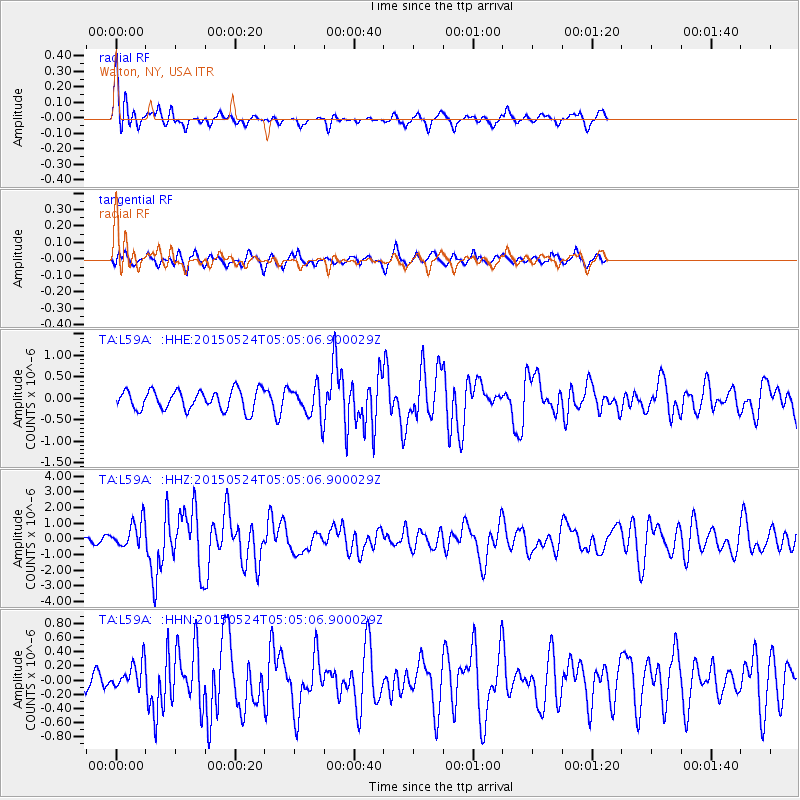
Signal To Noise
| Channel | StoN | STA | LTA |
| TA:L59A: :HHZ:20150524T05:05:06.900029Z | 4.220939 | 8.604518E-7 | 2.0385316E-7 |
| TA:L59A: :HHN:20150524T05:05:06.900029Z | 0.50805134 | 1.9300742E-7 | 3.7989747E-7 |
| TA:L59A: :HHE:20150524T05:05:06.900029Z | 1.6698537 | 3.8328014E-7 | 2.2952918E-7 |
| Arrivals |
| Ps | |
| PpPs | |
| PsPs/PpSs | |


