You are here: Home > Network List > TA - USArray Transportable Network (new EarthScope stations) Stations List
> Station L64A Middleborough, MA, USA > Earthquake Result Viewer
L64A Middleborough, MA, USA - Earthquake Result Viewer
| Earthquake location: |
Southern Mid-Atlantic Ridge |
| Earthquake latitude/longitude: |
-16.8/-14.2 |
| Earthquake time(UTC): |
2015/05/24 (144) 04:53:22 GMT |
| Earthquake Depth: |
10 km |
| Earthquake Magnitude: |
6.3 MWP |
| Earthquake Catalog/Contributor: |
NEIC PDE/NEIC COMCAT |
|
| Network: |
TA USArray Transportable Network (new EarthScope stations) |
| Station: |
L64A Middleborough, MA, USA |
| Lat/Lon: |
41.94 N/70.84 W |
| Elevation: |
17 m |
|
| Distance: |
78.4 deg |
| Az: |
320.484 deg |
| Baz: |
125.241 deg |
| Ray Param: |
0.0496725 |
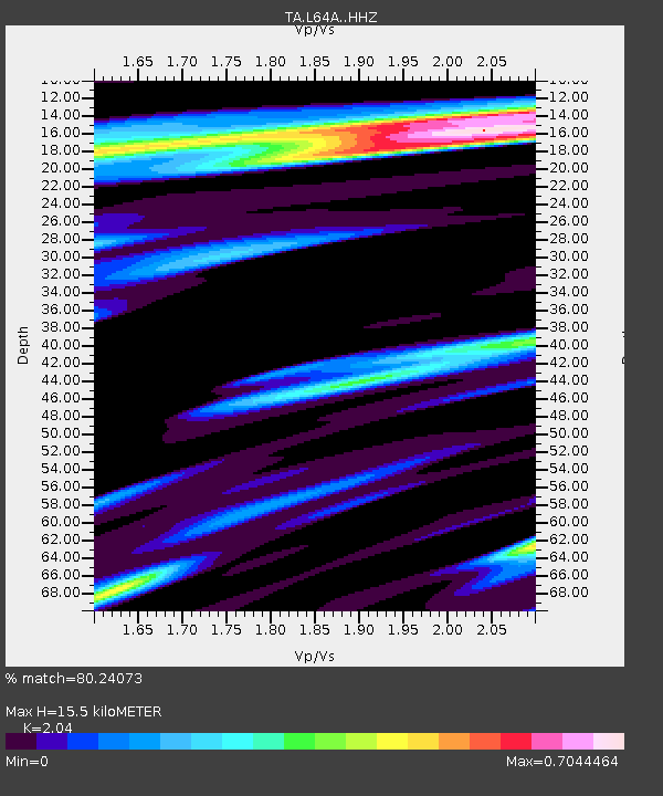
| Estimated Moho Depth: |
15.5 km |
| Estimated Crust Vp/Vs: |
2.04 |
| Assumed Crust Vp: |
6.472 km/s |
| Estimated Crust Vs: |
3.172 km/s |
| Estimated Crust Poisson's Ratio: |
0.34 |
|
| Radial Match: |
80.24073 % |
| Radial Bump: |
400 |
| Transverse Match: |
70.21687 % |
| Transverse Bump: |
400 |
| SOD ConfigId: |
7422571 |
| Insert Time: |
2019-04-19 01:08:09.068 +0000 |
| GWidth: |
2.5 |
| Max Bumps: |
400 |
| Tol: |
0.001 |
|

Signal To Noise
| Channel | StoN | STA | LTA |
| TA:L64A: :HHZ:20150524T05:04:52.060002Z | 1.9807924 | 6.4256415E-7 | 3.2439752E-7 |
| TA:L64A: :HHN:20150524T05:04:52.060002Z | 0.87331885 | 1.7653532E-7 | 2.0214303E-7 |
| TA:L64A: :HHE:20150524T05:04:52.060002Z | 0.7721122 | 2.4671138E-7 | 3.195279E-7 |
| Arrivals |
| Ps | 2.6 SECOND |
| PpPs | 7.1 SECOND |
| PsPs/PpSs | 9.6 SECOND |


