You are here: Home > Network List > TA - USArray Transportable Network (new EarthScope stations) Stations List
> Station O61A Allentown, NJ, USA > Earthquake Result Viewer
O61A Allentown, NJ, USA - Earthquake Result Viewer
| Earthquake location: |
Southern Mid-Atlantic Ridge |
| Earthquake latitude/longitude: |
-16.8/-14.2 |
| Earthquake time(UTC): |
2015/05/24 (144) 04:53:22 GMT |
| Earthquake Depth: |
10 km |
| Earthquake Magnitude: |
6.3 MWP |
| Earthquake Catalog/Contributor: |
NEIC PDE/NEIC COMCAT |
|
| Network: |
TA USArray Transportable Network (new EarthScope stations) |
| Station: |
O61A Allentown, NJ, USA |
| Lat/Lon: |
40.09 N/74.55 W |
| Elevation: |
38 m |
|
| Distance: |
79.7 deg |
| Az: |
317.336 deg |
| Baz: |
122.214 deg |
| Ray Param: |
0.04877541 |
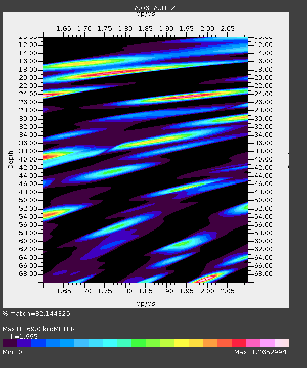
| Estimated Moho Depth: |
69.0 km |
| Estimated Crust Vp/Vs: |
2.00 |
| Assumed Crust Vp: |
6.283 km/s |
| Estimated Crust Vs: |
3.15 km/s |
| Estimated Crust Poisson's Ratio: |
0.33 |
|
| Radial Match: |
82.144325 % |
| Radial Bump: |
400 |
| Transverse Match: |
67.60733 % |
| Transverse Bump: |
400 |
| SOD ConfigId: |
7422571 |
| Insert Time: |
2019-04-19 01:08:20.305 +0000 |
| GWidth: |
2.5 |
| Max Bumps: |
400 |
| Tol: |
0.001 |
|
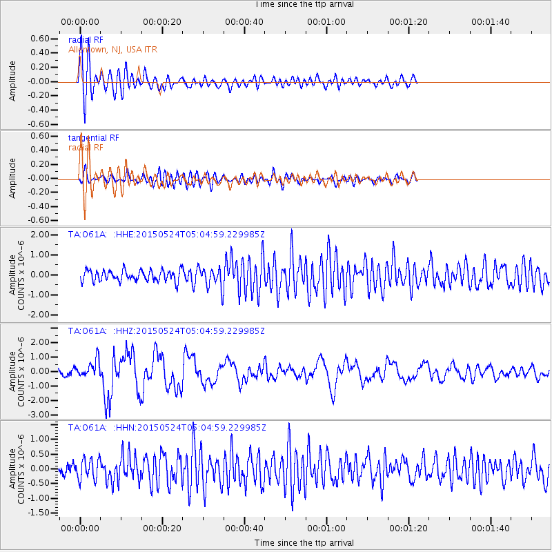
Signal To Noise
| Channel | StoN | STA | LTA |
| TA:O61A: :HHZ:20150524T05:04:59.229985Z | 3.5500522 | 6.1213706E-7 | 1.7243045E-7 |
| TA:O61A: :HHN:20150524T05:04:59.229985Z | 1.5682454 | 3.5705773E-7 | 2.2767975E-7 |
| TA:O61A: :HHE:20150524T05:04:59.229985Z | 1.922663 | 5.230325E-7 | 2.7203546E-7 |
| Arrivals |
| Ps | 11 SECOND |
| PpPs | 32 SECOND |
| PsPs/PpSs | 43 SECOND |


