You are here: Home > Network List > IU - Global Seismograph Network (GSN - IRIS/USGS) Stations List
> Station KEV Kevo, Finland > Earthquake Result Viewer
KEV Kevo, Finland - Earthquake Result Viewer

| Earthquake location: |
Northwest Of Kuril Islands |
| Earthquake latitude/longitude: |
47.8/146.2 |
| Earthquake time(UTC): |
2002/11/17 (321) 04:53:53 GMT |
| Earthquake Depth: |
459 km |
| Earthquake Magnitude: |
7.3 MW, 7.3 MW |
| Earthquake Catalog/Contributor: |
WHDF/NEIC |
|
| Network: |
IU Global Seismograph Network (GSN - IRIS/USGS) |
| Station: |
KEV Kevo, Finland |
| Lat/Lon: |
69.76 N/27.01 E |
| Elevation: |
80 m |
|
| Distance: |
54.7 deg |
| Az: |
338.136 deg |
| Baz: |
46.134 deg |
| Ray Param: |
0.06344872 |
| Estimated Moho Depth: |
40.75 km |
| Estimated Crust Vp/Vs: |
1.66 |
| Assumed Crust Vp: |
6.622 km/s |
| Estimated Crust Vs: |
3.977 km/s |
| Estimated Crust Poisson's Ratio: |
0.22 |
|
| Radial Match: |
94.20756 % |
| Radial Bump: |
400 |
| Transverse Match: |
69.86749 % |
| Transverse Bump: |
400 |
| SOD ConfigId: |
4714 |
| Insert Time: |
2010-03-02 15:29:52.313 +0000 |
| GWidth: |
2.5 |
| Max Bumps: |
400 |
| Tol: |
0.001 |
|
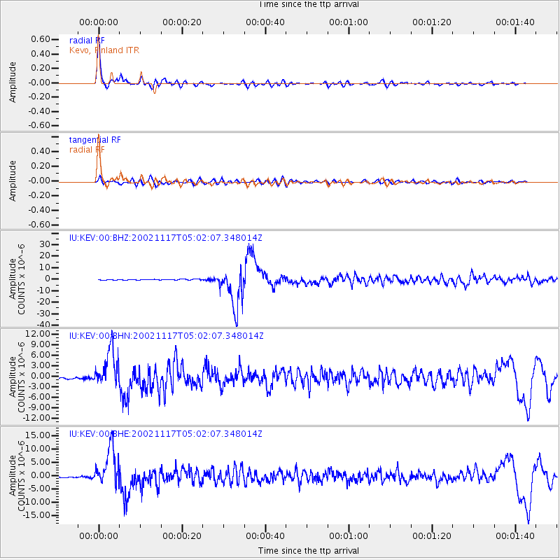
Signal To Noise
| Channel | StoN | STA | LTA |
| IU:KEV:00:BHN:20021117T05:02:07.348014Z | 36.566277 | 5.5420023E-6 | 1.5156047E-7 |
| IU:KEV:00:BHE:20021117T05:02:07.348014Z | 48.131187 | 7.515436E-6 | 1.5614484E-7 |
| IU:KEV:00:BHZ:20021117T05:02:07.348014Z | 56.340816 | 1.7588067E-5 | 3.1217272E-7 |
| Arrivals |
| Ps | 4.3 SECOND |
| PpPs | 15 SECOND |
| PsPs/PpSs | 20 SECOND |


