You are here: Home > Network List > TA - USArray Transportable Network (new EarthScope stations) Stations List
> Station Z41A Richland Creek Farm, El Dorado, AR, USA > Earthquake Result Viewer
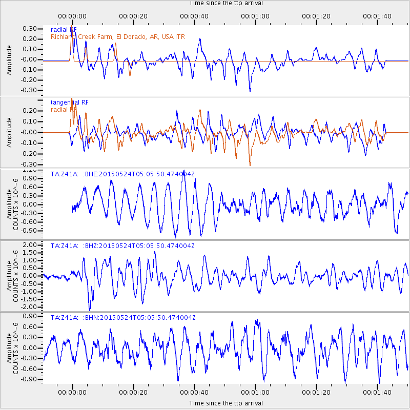
Z41A Richland Creek Farm, El Dorado, AR, USA - Earthquake Result Viewer
*The percent match for this event was below the threshold and hence no stack was calculated.
| Earthquake location: |
Southern Mid-Atlantic Ridge |
| Earthquake latitude/longitude: |
-16.8/-14.2 |
| Earthquake time(UTC): |
2015/05/24 (144) 04:53:22 GMT |
| Earthquake Depth: |
10 km |
| Earthquake Magnitude: |
6.3 MWP |
| Earthquake Catalog/Contributor: |
NEIC PDE/NEIC COMCAT |
|
| Network: |
TA USArray Transportable Network (new EarthScope stations) |
| Station: |
Z41A Richland Creek Farm, El Dorado, AR, USA |
| Lat/Lon: |
33.26 N/92.80 W |
| Elevation: |
62 m |
|
| Distance: |
89.9 deg |
| Az: |
304.773 deg |
| Baz: |
110.138 deg |
| Ray Param: |
$rayparam |
*The percent match for this event was below the threshold and hence was not used in the summary stack. |
|
| Radial Match: |
58.528202 % |
| Radial Bump: |
400 |
| Transverse Match: |
52.51606 % |
| Transverse Bump: |
400 |
| SOD ConfigId: |
7422571 |
| Insert Time: |
2019-04-19 01:08:31.656 +0000 |
| GWidth: |
2.5 |
| Max Bumps: |
400 |
| Tol: |
0.001 |
|
Signal To Noise
| Channel | StoN | STA | LTA |
| TA:Z41A: :BHZ:20150524T05:05:50.474004Z | 2.6119792 | 4.04894E-7 | 1.5501426E-7 |
| TA:Z41A: :BHN:20150524T05:05:50.474004Z | 0.71069175 | 2.8361032E-7 | 3.9906234E-7 |
| TA:Z41A: :BHE:20150524T05:05:50.474004Z | 1.8012708 | 7.151188E-7 | 3.9700794E-7 |
| Arrivals |
| Ps | |
| PpPs | |
| PsPs/PpSs | |


