You are here: Home > Network List > AZ - ANZA Regional Network Stations List
> Station LVA2 AZ.LVA2 > Earthquake Result Viewer
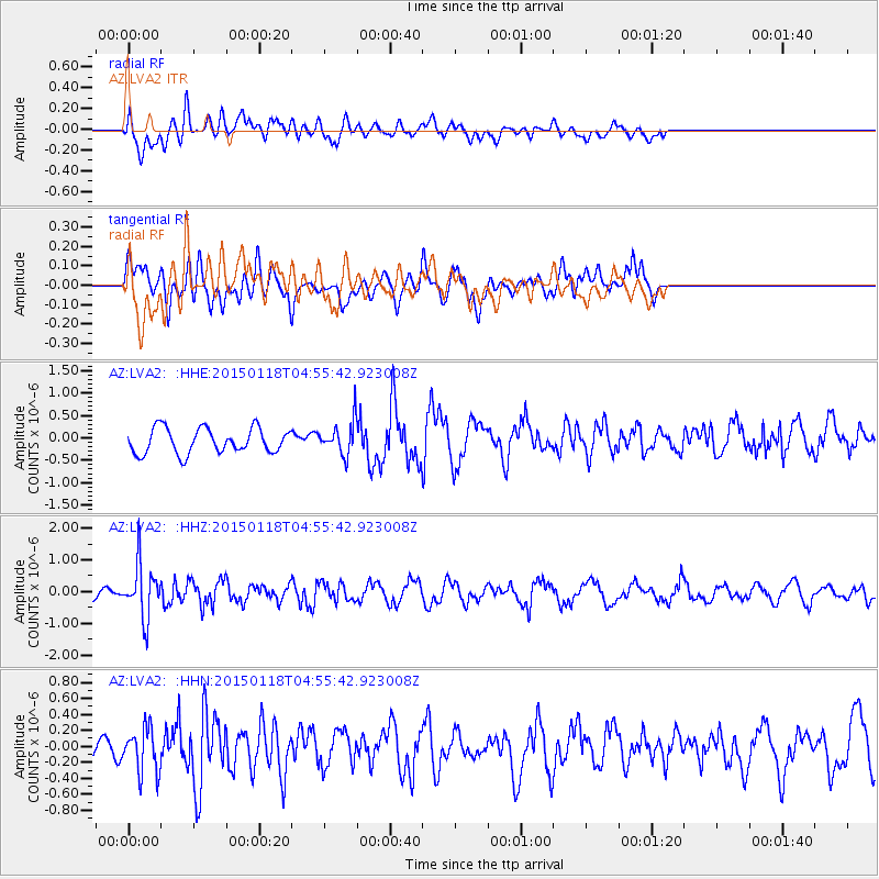
LVA2 AZ.LVA2 - Earthquake Result Viewer
*The percent match for this event was below the threshold and hence no stack was calculated.
| Earthquake location: |
Rat Islands, Aleutian Islands |
| Earthquake latitude/longitude: |
51.9/179.6 |
| Earthquake time(UTC): |
2015/01/18 (018) 04:47:38 GMT |
| Earthquake Depth: |
106 km |
| Earthquake Magnitude: |
5.8 MB, 5.9 MB |
| Earthquake Catalog/Contributor: |
NEIC PDE/NEIC COMCAT |
|
| Network: |
AZ ANZA Regional Network |
| Station: |
LVA2 AZ.LVA2 |
| Lat/Lon: |
33.35 N/116.56 W |
| Elevation: |
1435 m |
|
| Distance: |
48.9 deg |
| Az: |
86.219 deg |
| Baz: |
312.39 deg |
| Ray Param: |
$rayparam |
*The percent match for this event was below the threshold and hence was not used in the summary stack. |
|
| Radial Match: |
31.788668 % |
| Radial Bump: |
400 |
| Transverse Match: |
63.573643 % |
| Transverse Bump: |
400 |
| SOD ConfigId: |
837871 |
| Insert Time: |
2015-02-01 04:58:23.379 +0000 |
| GWidth: |
2.5 |
| Max Bumps: |
400 |
| Tol: |
0.001 |
|
Signal To Noise
| Channel | StoN | STA | LTA |
| AZ:LVA2: :HHZ:20150118T04:55:42.923008Z | 3.3875997 | 8.241722E-7 | 2.432909E-7 |
| AZ:LVA2: :HHN:20150118T04:55:42.923008Z | 1.4499002 | 2.8260965E-7 | 1.9491662E-7 |
| AZ:LVA2: :HHE:20150118T04:55:42.923008Z | 1.2829664 | 3.565144E-7 | 2.778829E-7 |
| Arrivals |
| Ps | |
| PpPs | |
| PsPs/PpSs | |


