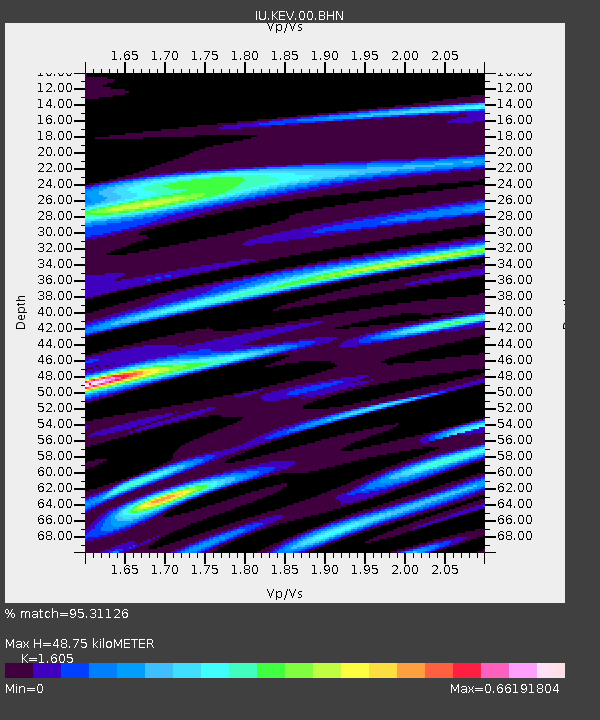
KEV Kevo, Finland - Earthquake Result Viewer
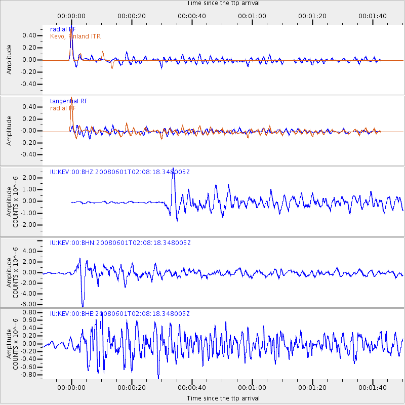
Earthquake location: Philippine Islands Region
Earthquake latitude/longitude: 20.1/121.4
Earthquake time(UTC): 2008/06/01 (153) 01:57:24 GMT
Earthquake Depth: 35 km
Earthquake Magnitude: 6.0 MB, 6.2 MS, 6.3 MW, 6.2 MW
Earthquake Catalog/Contributor: WHDF/NEIC
Network: IU Global Seismograph Network (GSN - IRIS/USGS)
Station: KEV Kevo, Finland
Lat/Lon: 69.76 N/27.01 E
Elevation: 80 m
Distance: 72.8 deg
Az: 338.695 deg
Baz: 78.767 deg
Ray Param: 0.05337383
Estimated Moho Depth: 48.75 km
Estimated Crust Vp/Vs: 1.61
Assumed Crust Vp: 6.622 km/s
Estimated Crust Vs: 4.126 km/s
Estimated Crust Poisson's Ratio: 0.18
Radial Match: 95.31126 %
Radial Bump: 327
Transverse Match: 88.24632 %
Transverse Bump: 400
SOD ConfigId: 2504
Insert Time: 2010-03-02 15:31:10.682 +0000
GWidth: 2.5
Max Bumps: 400
Tol: 0.001

Signal To Noise

ChannelStoNSTALTA
IU:KEV:00:BHN:20080601T02:08:18.348005Z31.9077152.5084055E-67.8614384E-8
IU:KEV:00:BHE:20080601T02:08:18.348005Z2.86022161.4842328E-75.1892233E-8
IU:KEV:00:BHZ:20080601T02:08:18.348005Z23.2129141.093987E-64.7128378E-8
Arrivals
Ps4.6 SECOND
PpPs18 SECOND
PsPs/PpSs23 SECOND