You are here: Home > Network List > IU - Global Seismograph Network (GSN - IRIS/USGS) Stations List
> Station KEV Kevo, Finland > Earthquake Result Viewer
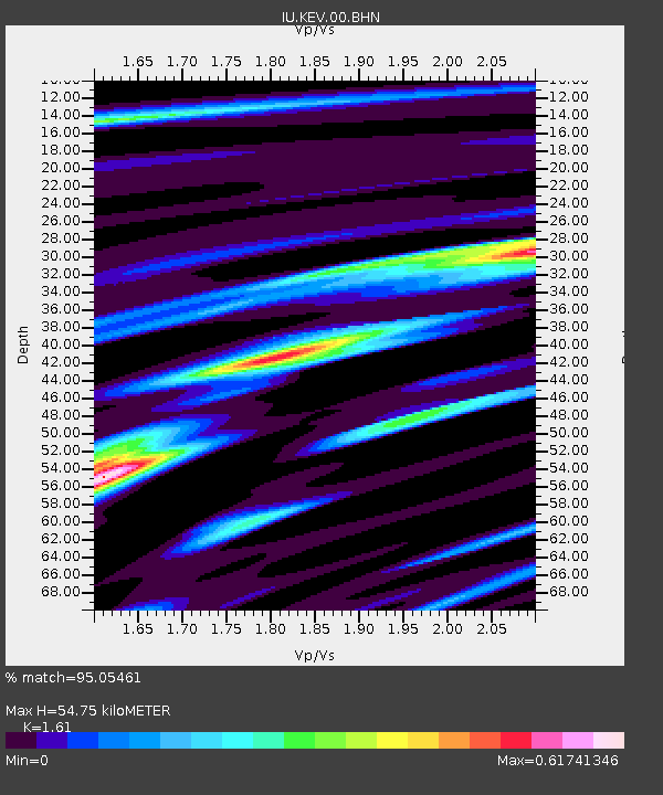
KEV Kevo, Finland - Earthquake Result Viewer
| Earthquake location: |
Xizang |
| Earthquake latitude/longitude: |
30.9/83.5 |
| Earthquake time(UTC): |
2008/08/25 (238) 13:21:58 GMT |
| Earthquake Depth: |
12 km |
| Earthquake Magnitude: |
6.2 MB, 6.5 MS, 6.7 MW, 6.7 MW |
| Earthquake Catalog/Contributor: |
WHDF/NEIC |
|
| Network: |
IU Global Seismograph Network (GSN - IRIS/USGS) |
| Station: |
KEV Kevo, Finland |
| Lat/Lon: |
69.76 N/27.01 E |
| Elevation: |
80 m |
|
| Distance: |
49.9 deg |
| Az: |
337.695 deg |
| Baz: |
110.408 deg |
| Ray Param: |
0.06840264 |
| Estimated Moho Depth: |
54.75 km |
| Estimated Crust Vp/Vs: |
1.61 |
| Assumed Crust Vp: |
6.622 km/s |
| Estimated Crust Vs: |
4.113 km/s |
| Estimated Crust Poisson's Ratio: |
0.19 |
|
| Radial Match: |
95.05461 % |
| Radial Bump: |
367 |
| Transverse Match: |
81.66104 % |
| Transverse Bump: |
400 |
| SOD ConfigId: |
2504 |
| Insert Time: |
2010-03-02 15:31:32.593 +0000 |
| GWidth: |
2.5 |
| Max Bumps: |
400 |
| Tol: |
0.001 |
|

Signal To Noise
| Channel | StoN | STA | LTA |
| IU:KEV:00:BHN:20080825T13:30:21.161003Z | 15.580227 | 2.6684809E-6 | 1.7127356E-7 |
| IU:KEV:00:BHE:20080825T13:30:21.161003Z | 8.857105 | 7.2953185E-7 | 8.2366846E-8 |
| IU:KEV:00:BHZ:20080825T13:30:21.161003Z | 11.30802 | 1.443422E-6 | 1.2764588E-7 |
| Arrivals |
| Ps | 5.4 SECOND |
| PpPs | 20 SECOND |
| PsPs/PpSs | 26 SECOND |


