You are here: Home > Network List > ZJ12 - Transantarctic Mountains Northern Network Stations List
> Station DUBY Mt Kring, Antarctica > Earthquake Result Viewer
DUBY Mt Kring, Antarctica - Earthquake Result Viewer
| Earthquake location: |
Tonga Islands |
| Earthquake latitude/longitude: |
-19.3/-175.9 |
| Earthquake time(UTC): |
2015/05/24 (144) 14:39:02 GMT |
| Earthquake Depth: |
35 km |
| Earthquake Magnitude: |
5.7 MB |
| Earthquake Catalog/Contributor: |
NEIC PDE/NEIC COMCAT |
|
| Network: |
ZJ Transantarctic Mountains Northern Network |
| Station: |
DUBY Mt Kring, Antarctica |
| Lat/Lon: |
74.99 S/158.08 E |
| Elevation: |
1508 m |
|
| Distance: |
57.4 deg |
| Az: |
187.791 deg |
| Baz: |
29.41 deg |
| Ray Param: |
0.06345977 |
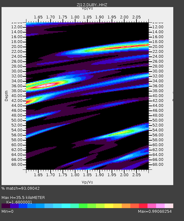
| Estimated Moho Depth: |
35.5 km |
| Estimated Crust Vp/Vs: |
1.68 |
| Assumed Crust Vp: |
6.182 km/s |
| Estimated Crust Vs: |
3.679 km/s |
| Estimated Crust Poisson's Ratio: |
0.23 |
|
| Radial Match: |
93.09042 % |
| Radial Bump: |
311 |
| Transverse Match: |
76.149345 % |
| Transverse Bump: |
400 |
| SOD ConfigId: |
7422571 |
| Insert Time: |
2019-04-19 01:23:19.257 +0000 |
| GWidth: |
2.5 |
| Max Bumps: |
400 |
| Tol: |
0.001 |
|

Signal To Noise
| Channel | StoN | STA | LTA |
| ZJ:DUBY: :HHZ:20150524T14:48:16.028994Z | 5.755923 | 9.3704824E-7 | 1.6279722E-7 |
| ZJ:DUBY: :HHN:20150524T14:48:16.028994Z | 2.3243582 | 4.085666E-7 | 1.7577608E-7 |
| ZJ:DUBY: :HHE:20150524T14:48:16.028994Z | 1.6438371 | 2.617684E-7 | 1.5924229E-7 |
| Arrivals |
| Ps | 4.1 SECOND |
| PpPs | 15 SECOND |
| PsPs/PpSs | 19 SECOND |


