You are here: Home > Network List > YT07 - POLENET Stations List
> Station KOLR KOLR > Earthquake Result Viewer
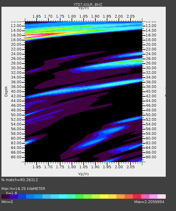
KOLR KOLR - Earthquake Result Viewer
| Earthquake location: |
South Sandwich Islands Region |
| Earthquake latitude/longitude: |
-59.6/-26.4 |
| Earthquake time(UTC): |
2015/05/24 (144) 21:06:41 GMT |
| Earthquake Depth: |
37 km |
| Earthquake Magnitude: |
5.8 MB |
| Earthquake Catalog/Contributor: |
NEIC PDE/NEIC COMCAT |
|
| Network: |
YT POLENET |
| Station: |
KOLR KOLR |
| Lat/Lon: |
76.15 S/120.73 W |
| Elevation: |
1888 m |
|
| Distance: |
34.2 deg |
| Az: |
205.271 deg |
| Baz: |
115.807 deg |
| Ray Param: |
0.07777909 |
| Estimated Moho Depth: |
16.25 km |
| Estimated Crust Vp/Vs: |
1.60 |
| Assumed Crust Vp: |
6.095 km/s |
| Estimated Crust Vs: |
3.809 km/s |
| Estimated Crust Poisson's Ratio: |
0.18 |
|
| Radial Match: |
90.26312 % |
| Radial Bump: |
400 |
| Transverse Match: |
76.10245 % |
| Transverse Bump: |
400 |
| SOD ConfigId: |
7422571 |
| Insert Time: |
2019-04-19 01:25:53.121 +0000 |
| GWidth: |
2.5 |
| Max Bumps: |
400 |
| Tol: |
0.001 |
|

Signal To Noise
| Channel | StoN | STA | LTA |
| YT:KOLR: :BHZ:20150524T21:12:53.048999Z | 22.626612 | 2.1000217E-6 | 9.281202E-8 |
| YT:KOLR: :BHN:20150524T21:12:53.048999Z | 1.9322207 | 2.7513346E-7 | 1.4239235E-7 |
| YT:KOLR: :BHE:20150524T21:12:53.048999Z | 3.7279341 | 5.469611E-7 | 1.4671961E-7 |
| Arrivals |
| Ps | 1.7 SECOND |
| PpPs | 6.4 SECOND |
| PsPs/PpSs | 8.1 SECOND |


