You are here: Home > Network List > YT07 - POLENET Stations List
> Station MPAT MPAT > Earthquake Result Viewer
MPAT MPAT - Earthquake Result Viewer
| Earthquake location: |
South Sandwich Islands Region |
| Earthquake latitude/longitude: |
-59.6/-26.4 |
| Earthquake time(UTC): |
2015/05/24 (144) 21:06:41 GMT |
| Earthquake Depth: |
37 km |
| Earthquake Magnitude: |
5.8 MB |
| Earthquake Catalog/Contributor: |
NEIC PDE/NEIC COMCAT |
|
| Network: |
YT POLENET |
| Station: |
MPAT MPAT |
| Lat/Lon: |
78.03 S/155.02 W |
| Elevation: |
540 m |
|
| Distance: |
39.1 deg |
| Az: |
194.987 deg |
| Baz: |
141.012 deg |
| Ray Param: |
0.07511473 |
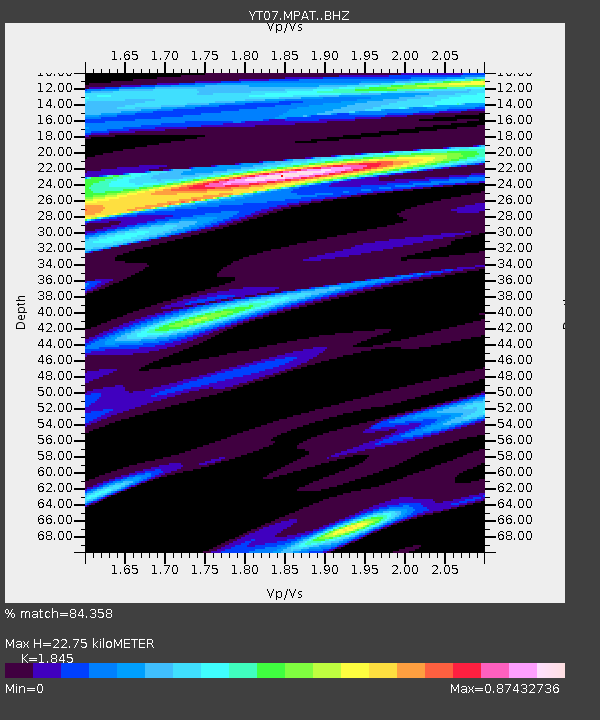
| Estimated Moho Depth: |
22.75 km |
| Estimated Crust Vp/Vs: |
1.85 |
| Assumed Crust Vp: |
6.43 km/s |
| Estimated Crust Vs: |
3.485 km/s |
| Estimated Crust Poisson's Ratio: |
0.29 |
|
| Radial Match: |
84.358 % |
| Radial Bump: |
380 |
| Transverse Match: |
48.55754 % |
| Transverse Bump: |
400 |
| SOD ConfigId: |
7422571 |
| Insert Time: |
2019-04-19 01:25:56.568 +0000 |
| GWidth: |
2.5 |
| Max Bumps: |
400 |
| Tol: |
0.001 |
|

Signal To Noise
| Channel | StoN | STA | LTA |
| YT:MPAT: :BHZ:20150524T21:13:34.175006Z | 6.6176744 | 9.3167836E-7 | 1.4078637E-7 |
| YT:MPAT: :BHN:20150524T21:13:34.175006Z | 4.520433 | 4.55616E-7 | 1.00790345E-7 |
| YT:MPAT: :BHE:20150524T21:13:34.175006Z | 3.4276438 | 3.5691906E-7 | 1.0412956E-7 |
| Arrivals |
| Ps | 3.2 SECOND |
| PpPs | 9.4 SECOND |
| PsPs/PpSs | 13 SECOND |


