You are here: Home > Network List > IU - Global Seismograph Network (GSN - IRIS/USGS) Stations List
> Station KEV Kevo, Finland > Earthquake Result Viewer
KEV Kevo, Finland - Earthquake Result Viewer
| Earthquake location: |
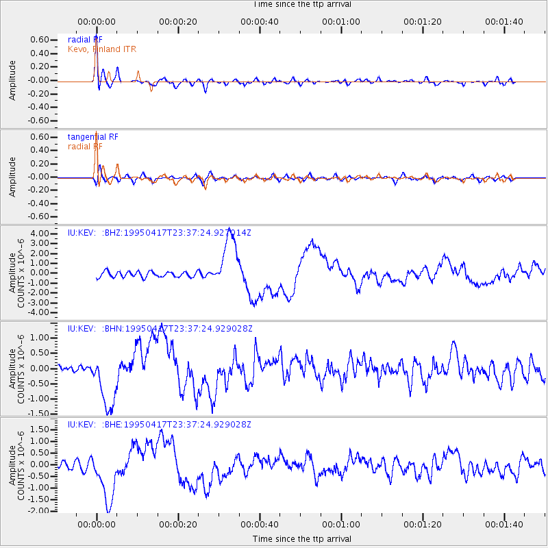
Kuril Islands |
| Earthquake latitude/longitude: |
45.9/151.3 |
| Earthquake time(UTC): |
1995/04/17 (107) 23:28:08 GMT |
| Earthquake Depth: |
34 km |
| Earthquake Magnitude: |
6.1 MB, 6.3 MS, 6.2 UNKNOWN, 6.8 MW |
| Earthquake Catalog/Contributor: |
WHDF/NEIC |
|
| Network: |
IU Global Seismograph Network (GSN - IRIS/USGS) |
| Station: |
KEV Kevo, Finland |
| Lat/Lon: |
69.76 N/27.01 E |
| Elevation: |
80 m |
|
| Distance: |
57.7 deg |
| Az: |
340.11 deg |
| Baz: |
43.039 deg |
| Ray Param: |
0.06325664 |
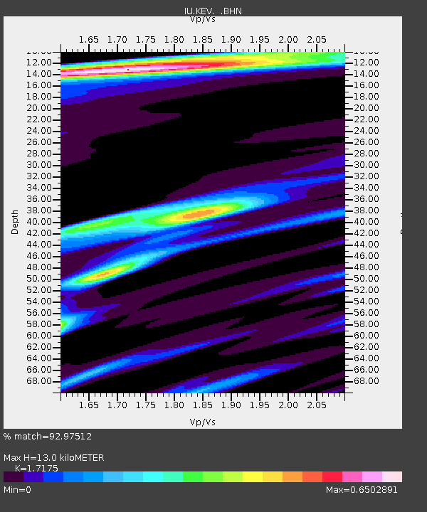
| Estimated Moho Depth: |
13.0 km |
| Estimated Crust Vp/Vs: |
1.72 |
| Assumed Crust Vp: |
6.622 km/s |
| Estimated Crust Vs: |
3.856 km/s |
| Estimated Crust Poisson's Ratio: |
0.24 |
|
| Radial Match: |
92.97512 % |
| Radial Bump: |
400 |
| Transverse Match: |
65.32159 % |
| Transverse Bump: |
400 |
| SOD ConfigId: |
6273 |
| Insert Time: |
2010-03-02 15:33:04.334 +0000 |
| GWidth: |
2.5 |
| Max Bumps: |
400 |
| Tol: |
0.001 |
|
Signal To Noise
| Channel | StoN | STA | LTA |
| IU:KEV: :BHN:19950417T23:37:24.929028Z | 4.468046 | 9.550439E-7 | 2.1374977E-7 |
| IU:KEV: :BHE:19950417T23:37:24.929028Z | 9.7280035 | 1.1366499E-6 | 1.16843076E-7 |
| IU:KEV: :BHZ:19950417T23:37:24.927014Z | 9.810406 | 2.7655353E-6 | 2.8189817E-7 |
| Arrivals |
| Ps | 1.5 SECOND |
| PpPs | 5.1 SECOND |
| PsPs/PpSs | 6.5 SECOND |


