You are here: Home > Network List > CI - Caltech Regional Seismic Network Stations List
> Station MPM Manuel Prospect Mine, California, USA > Earthquake Result Viewer
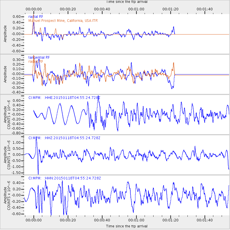
MPM Manuel Prospect Mine, California, USA - Earthquake Result Viewer
*The percent match for this event was below the threshold and hence no stack was calculated.
| Earthquake location: |
Rat Islands, Aleutian Islands |
| Earthquake latitude/longitude: |
51.9/179.6 |
| Earthquake time(UTC): |
2015/01/18 (018) 04:47:38 GMT |
| Earthquake Depth: |
106 km |
| Earthquake Magnitude: |
5.8 MB, 5.9 MB |
| Earthquake Catalog/Contributor: |
NEIC PDE/NEIC COMCAT |
|
| Network: |
CI Caltech Regional Seismic Network |
| Station: |
MPM Manuel Prospect Mine, California, USA |
| Lat/Lon: |
36.06 N/117.49 W |
| Elevation: |
185 m |
|
| Distance: |
46.5 deg |
| Az: |
84.165 deg |
| Baz: |
310.481 deg |
| Ray Param: |
$rayparam |
*The percent match for this event was below the threshold and hence was not used in the summary stack. |
|
| Radial Match: |
74.316734 % |
| Radial Bump: |
400 |
| Transverse Match: |
63.874954 % |
| Transverse Bump: |
392 |
| SOD ConfigId: |
837871 |
| Insert Time: |
2015-02-01 05:00:59.416 +0000 |
| GWidth: |
2.5 |
| Max Bumps: |
400 |
| Tol: |
0.001 |
|
Signal To Noise
| Channel | StoN | STA | LTA |
| CI:MPM: :HHZ:20150118T04:55:24.728Z | 6.499185 | 6.481459E-7 | 9.972725E-8 |
| CI:MPM: :HHN:20150118T04:55:24.728Z | 1.3198783 | 2.6785742E-7 | 2.0294098E-7 |
| CI:MPM: :HHE:20150118T04:55:24.728Z | 1.1790869 | 2.7670126E-7 | 2.3467419E-7 |
| Arrivals |
| Ps | |
| PpPs | |
| PsPs/PpSs | |


