You are here: Home > Network List > CI - Caltech Regional Seismic Network Stations List
> Station SWS Sam W. Stewart, Westmorland, CA, USA > Earthquake Result Viewer
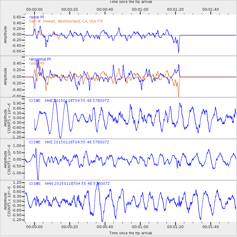
SWS Sam W. Stewart, Westmorland, CA, USA - Earthquake Result Viewer
*The percent match for this event was below the threshold and hence no stack was calculated.
| Earthquake location: |
Rat Islands, Aleutian Islands |
| Earthquake latitude/longitude: |
51.9/179.6 |
| Earthquake time(UTC): |
2015/01/18 (018) 04:47:38 GMT |
| Earthquake Depth: |
106 km |
| Earthquake Magnitude: |
5.8 MB, 5.9 MB |
| Earthquake Catalog/Contributor: |
NEIC PDE/NEIC COMCAT |
|
| Network: |
CI Caltech Regional Seismic Network |
| Station: |
SWS Sam W. Stewart, Westmorland, CA, USA |
| Lat/Lon: |
32.94 N/115.80 W |
| Elevation: |
140 m |
|
| Distance: |
49.6 deg |
| Az: |
86.044 deg |
| Baz: |
312.692 deg |
| Ray Param: |
$rayparam |
*The percent match for this event was below the threshold and hence was not used in the summary stack. |
|
| Radial Match: |
43.3836 % |
| Radial Bump: |
400 |
| Transverse Match: |
80.007545 % |
| Transverse Bump: |
339 |
| SOD ConfigId: |
837871 |
| Insert Time: |
2015-02-01 05:01:58.460 +0000 |
| GWidth: |
2.5 |
| Max Bumps: |
400 |
| Tol: |
0.001 |
|
Signal To Noise
| Channel | StoN | STA | LTA |
| CI:SWS: :HHZ:20150118T04:55:48.578007Z | 1.8363008 | 6.3880105E-7 | 3.4787385E-7 |
| CI:SWS: :HHN:20150118T04:55:48.578007Z | 0.30844072 | 1.6251239E-7 | 5.2688375E-7 |
| CI:SWS: :HHE:20150118T04:55:48.578007Z | 0.5098543 | 3.167432E-7 | 6.212426E-7 |
| Arrivals |
| Ps | |
| PpPs | |
| PsPs/PpSs | |


