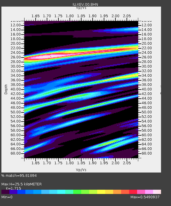
KEV Kevo, Finland - Earthquake Result Viewer
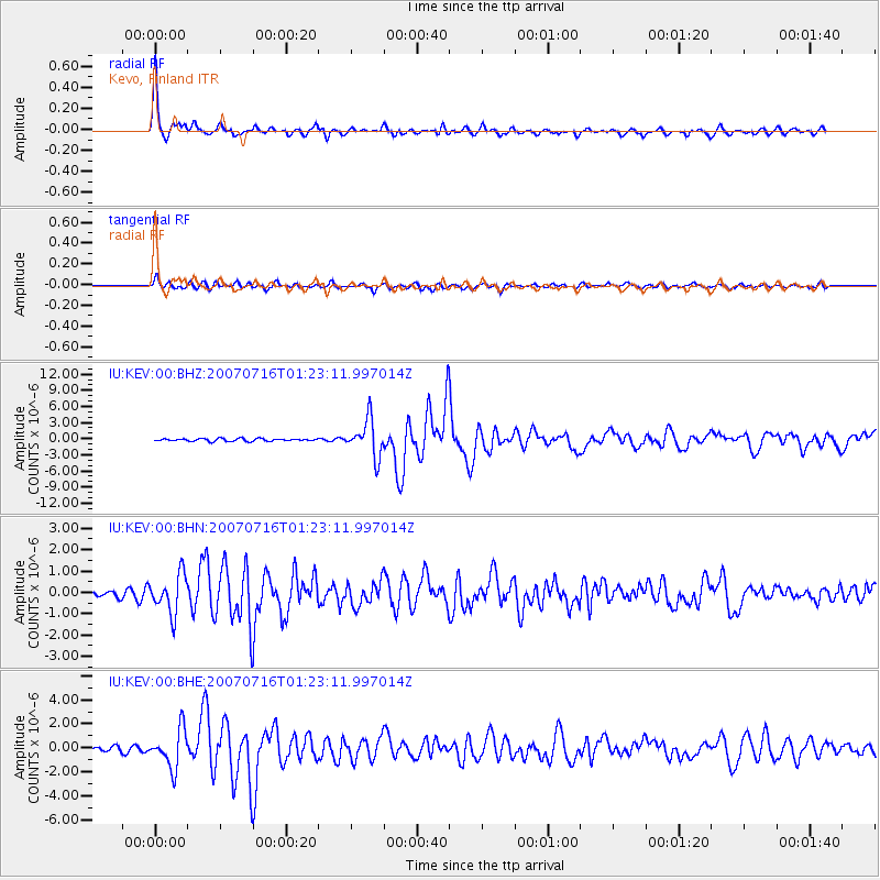
Earthquake location: Near West Coast Of Honshu, Japan
Earthquake latitude/longitude: 37.5/138.4
Earthquake time(UTC): 2007/07/16 (197) 01:13:22 GMT
Earthquake Depth: 12 km
Earthquake Magnitude: 6.5 MB, 6.4 MS, 6.6 MW, 6.5 MW
Earthquake Catalog/Contributor: WHDF/NEIC
Network: IU Global Seismograph Network (GSN - IRIS/USGS)
Station: KEV Kevo, Finland
Lat/Lon: 69.76 N/27.01 E
Elevation: 80 m
Distance: 62.1 deg
Az: 338.498 deg
Baz: 56.835 deg
Ray Param: 0.06043109
Estimated Moho Depth: 25.5 km
Estimated Crust Vp/Vs: 1.72
Assumed Crust Vp: 6.622 km/s
Estimated Crust Vs: 3.861 km/s
Estimated Crust Poisson's Ratio: 0.24
Radial Match: 95.81894 %
Radial Bump: 353
Transverse Match: 85.36813 %
Transverse Bump: 400
SOD ConfigId: 2564
Insert Time: 2010-03-02 15:35:02.685 +0000
GWidth: 2.5
Max Bumps: 400
Tol: 0.001

Signal To Noise

ChannelStoNSTALTA
IU:KEV:00:BHN:20070716T01:23:11.997014Z5.8780359.035519E-71.5371666E-7
IU:KEV:00:BHE:20070716T01:23:11.997014Z9.3286321.5876667E-61.7019288E-7
IU:KEV:00:BHZ:20070716T01:23:11.997014Z14.1902123.4249485E-62.413599E-7
Arrivals
Ps2.9 SECOND
PpPs10.0 SECOND
PsPs/PpSs13 SECOND