KEV Kevo, Finland - Earthquake Result Viewer
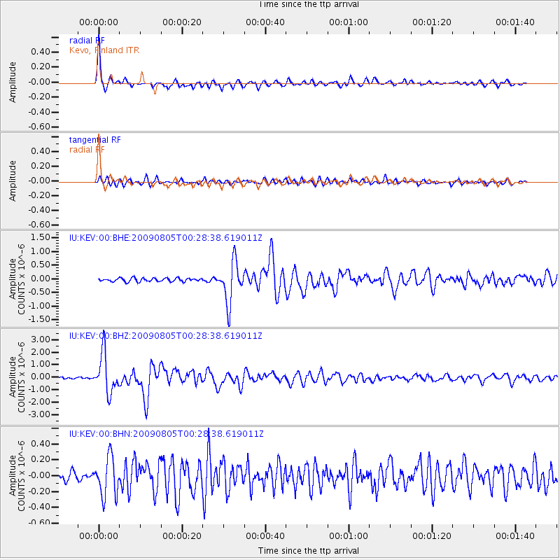
Earthquake location: Southwestern Ryukyu Isl., Japan
Earthquake latitude/longitude: 24.2/125.1
Earthquake time(UTC): 2009/08/05 (217) 00:17:58 GMT
Earthquake Depth: 25 km
Earthquake Magnitude: 5.9 MB, 5.9 MS, 6.2 MW, 6.1 MW
Earthquake Catalog/Contributor: WHDF/NEIC
Network: IU Global Seismograph Network (GSN - IRIS/USGS)
Station: KEV Kevo, Finland
Lat/Lon: 69.76 N/27.00 E
Elevation: 100 m
Distance: 70.3 deg
Az: 338.523 deg
Baz: 73.803 deg
Ray Param: 0.055075817
Estimated Moho Depth: 43.0 km
Estimated Crust Vp/Vs: 1.96
Assumed Crust Vp: 6.622 km/s
Estimated Crust Vs: 3.387 km/s
Estimated Crust Poisson's Ratio: 0.32
Radial Match: 94.3274 %
Radial Bump: 327
Transverse Match: 86.29025 %
Transverse Bump: 400
SOD ConfigId: 2622
Insert Time: 2010-03-02 15:35:14.501 +0000
GWidth: 2.5
Max Bumps: 400
Tol: 0.001

Signal To Noise

ChannelStoNSTALTA
IU:KEV:00:BHZ:20090805T00:28:38.619011Z19.8748991.592455E-68.012393E-8
IU:KEV:00:BHN:20090805T00:28:38.619011Z6.52742962.514101E-73.8515942E-8
IU:KEV:00:BHE:20090805T00:28:38.619011Z12.5613967.766366E-76.182726E-8
Arrivals
Ps6.4 SECOND
PpPs19 SECOND
PsPs/PpSs25 SECOND