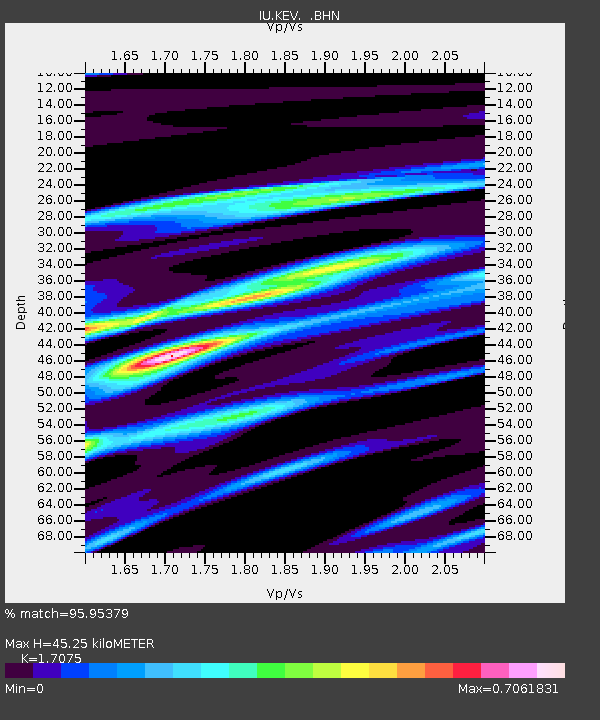
KEV Kevo, Finland - Earthquake Result Viewer
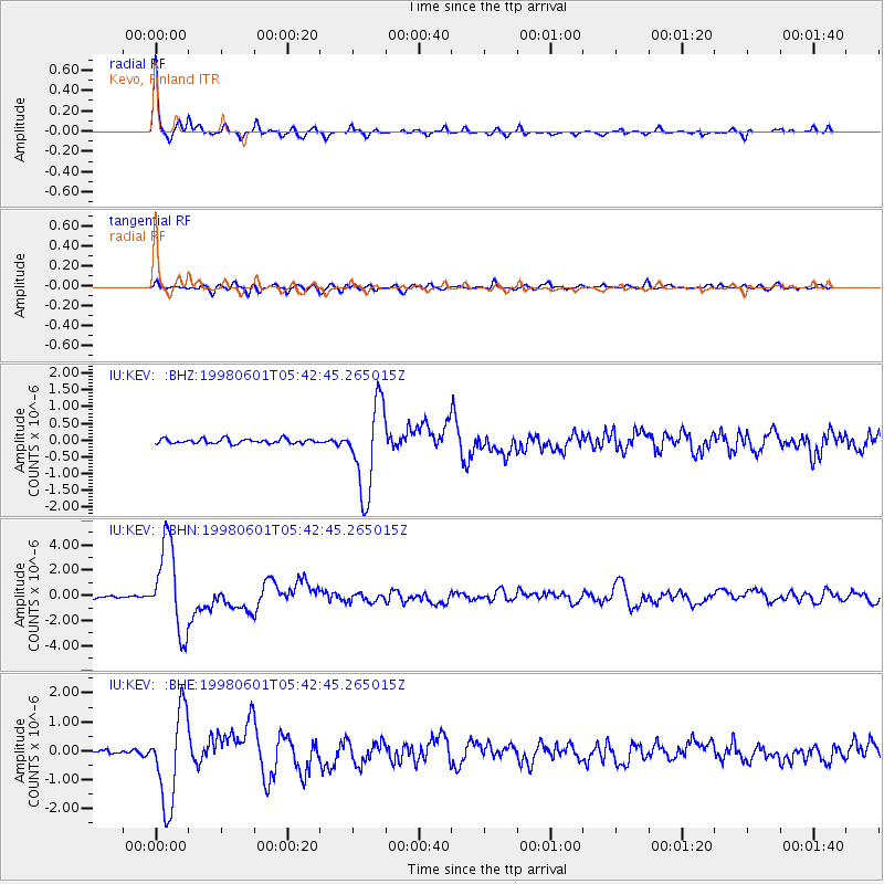
Earthquake location: Off East Coast Of Kamchatka
Earthquake latitude/longitude: 52.9/160.1
Earthquake time(UTC): 1998/06/01 (152) 05:34:03 GMT
Earthquake Depth: 44 km
Earthquake Magnitude: 6.2 MB, 6.3 MS, 6.5 UNKNOWN, 6.4 MW
Earthquake Catalog/Contributor: WHDF/NEIC
Network: IU Global Seismograph Network (GSN - IRIS/USGS)
Station: KEV Kevo, Finland
Lat/Lon: 69.76 N/27.01 E
Elevation: 80 m
Distance: 53.0 deg
Az: 341.432 deg
Baz: 33.664 deg
Ray Param: 0.066287436
Estimated Moho Depth: 45.25 km
Estimated Crust Vp/Vs: 1.71
Assumed Crust Vp: 6.622 km/s
Estimated Crust Vs: 3.878 km/s
Estimated Crust Poisson's Ratio: 0.24
Radial Match: 95.95379 %
Radial Bump: 297
Transverse Match: 79.479225 %
Transverse Bump: 400
SOD ConfigId: 4480
Insert Time: 2010-03-02 15:35:33.721 +0000
GWidth: 2.5
Max Bumps: 400
Tol: 0.001

Signal To Noise

ChannelStoNSTALTA
IU:KEV: :BHN:19980601T05:42:45.265015Z30.908123.4588995E-61.11909095E-7
IU:KEV: :BHE:19980601T05:42:45.265015Z27.1458741.5883417E-65.851135E-8
IU:KEV: :BHZ:19980601T05:42:45.265015Z19.0719871.3102382E-66.869961E-8
Arrivals
Ps5.1 SECOND
PpPs17 SECOND
PsPs/PpSs23 SECOND