You are here: Home > Network List > TA - USArray Transportable Network (new EarthScope stations) Stations List
> Station G59A Clarenceville, QC, USA > Earthquake Result Viewer
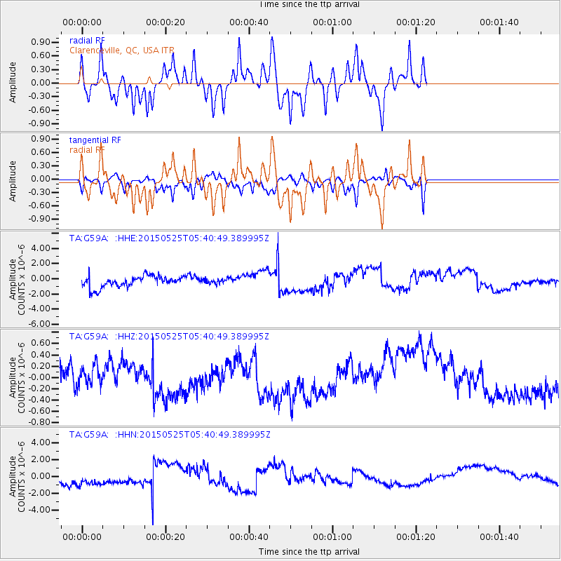
G59A Clarenceville, QC, USA - Earthquake Result Viewer
*The percent match for this event was below the threshold and hence no stack was calculated.
| Earthquake location: |
Eastern Honshu, Japan |
| Earthquake latitude/longitude: |
36.0/139.6 |
| Earthquake time(UTC): |
2015/05/25 (145) 05:28:09 GMT |
| Earthquake Depth: |
62 km |
| Earthquake Magnitude: |
5.2 MW, 5.3 mb |
| Earthquake Catalog/Contributor: |
ISC/ISC |
|
| Network: |
TA USArray Transportable Network (new EarthScope stations) |
| Station: |
G59A Clarenceville, QC, USA |
| Lat/Lon: |
45.08 N/73.18 W |
| Elevation: |
36 m |
|
| Distance: |
94.0 deg |
| Az: |
22.626 deg |
| Baz: |
333.885 deg |
| Ray Param: |
$rayparam |
*The percent match for this event was below the threshold and hence was not used in the summary stack. |
|
| Radial Match: |
69.20605 % |
| Radial Bump: |
390 |
| Transverse Match: |
40.980644 % |
| Transverse Bump: |
381 |
| SOD ConfigId: |
7422571 |
| Insert Time: |
2019-04-19 01:38:48.603 +0000 |
| GWidth: |
2.5 |
| Max Bumps: |
400 |
| Tol: |
0.001 |
|
Signal To Noise
| Channel | StoN | STA | LTA |
| TA:G59A: :HHZ:20150525T05:40:49.389995Z | 0.4342416 | 1.970825E-7 | 4.538545E-7 |
| TA:G59A: :HHN:20150525T05:40:49.389995Z | 1.7877874 | 1.3657067E-6 | 7.639089E-7 |
| TA:G59A: :HHE:20150525T05:40:49.389995Z | 0.3931648 | 2.9494063E-7 | 7.501705E-7 |
| Arrivals |
| Ps | |
| PpPs | |
| PsPs/PpSs | |


