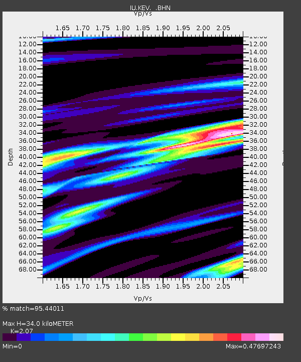
KEV Kevo, Finland - Earthquake Result Viewer
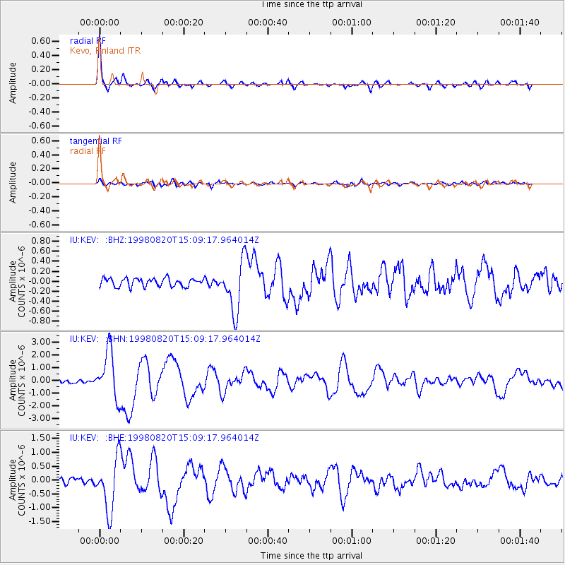
Earthquake location: Rat Islands, Aleutian Islands
Earthquake latitude/longitude: 51.6/175.2
Earthquake time(UTC): 1998/08/20 (232) 15:00:08 GMT
Earthquake Depth: 33 km
Earthquake Magnitude: 5.6 MB, 6.0 MS, 6.2 UNKNOWN, 6.2 MW
Earthquake Catalog/Contributor: WHDF/NEIC
Network: IU Global Seismograph Network (GSN - IRIS/USGS)
Station: KEV Kevo, Finland
Lat/Lon: 69.76 N/27.01 E
Elevation: 80 m
Distance: 56.7 deg
Az: 347.344 deg
Baz: 23.106 deg
Ray Param: 0.06388509
Estimated Moho Depth: 34.0 km
Estimated Crust Vp/Vs: 2.07
Assumed Crust Vp: 6.622 km/s
Estimated Crust Vs: 3.199 km/s
Estimated Crust Poisson's Ratio: 0.35
Radial Match: 95.44011 %
Radial Bump: 335
Transverse Match: 75.14266 %
Transverse Bump: 400
SOD ConfigId: 4480
Insert Time: 2010-03-02 15:35:52.742 +0000
GWidth: 2.5
Max Bumps: 400
Tol: 0.001

Signal To Noise

ChannelStoNSTALTA
IU:KEV: :BHN:19980820T15:09:17.964014Z17.3936021.9330748E-61.11137126E-7
IU:KEV: :BHE:19980820T15:09:17.964014Z10.9726829.751252E-78.8868454E-8
IU:KEV: :BHZ:19980820T15:09:17.964014Z6.53680565.323459E-78.143822E-8
Arrivals
Ps5.8 SECOND
PpPs15 SECOND
PsPs/PpSs21 SECOND