You are here: Home > Network List > X812 - Deep Structure of Three Continental Sutures in Eastern North America Stations List
> Station QM12 Camp Vic, Maine, USA > Earthquake Result Viewer
QM12 Camp Vic, Maine, USA - Earthquake Result Viewer
| Earthquake location: |
Eastern Honshu, Japan |
| Earthquake latitude/longitude: |
36.0/139.6 |
| Earthquake time(UTC): |
2015/05/25 (145) 05:28:09 GMT |
| Earthquake Depth: |
62 km |
| Earthquake Magnitude: |
5.2 MW, 5.3 mb |
| Earthquake Catalog/Contributor: |
ISC/ISC |
|
| Network: |
X8 Deep Structure of Three Continental Sutures in Eastern North America |
| Station: |
QM12 Camp Vic, Maine, USA |
| Lat/Lon: |
44.97 N/67.86 W |
| Elevation: |
15 m |
|
| Distance: |
95.6 deg |
| Az: |
19.216 deg |
| Baz: |
337.921 deg |
| Ray Param: |
0.040693928 |
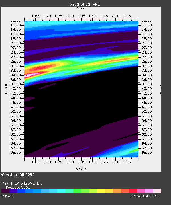
| Estimated Moho Depth: |
34.0 km |
| Estimated Crust Vp/Vs: |
1.61 |
| Assumed Crust Vp: |
6.419 km/s |
| Estimated Crust Vs: |
3.993 km/s |
| Estimated Crust Poisson's Ratio: |
0.18 |
|
| Radial Match: |
85.2052 % |
| Radial Bump: |
400 |
| Transverse Match: |
87.00521 % |
| Transverse Bump: |
400 |
| SOD ConfigId: |
7422571 |
| Insert Time: |
2019-04-19 01:40:13.020 +0000 |
| GWidth: |
2.5 |
| Max Bumps: |
400 |
| Tol: |
0.001 |
|

Signal To Noise
| Channel | StoN | STA | LTA |
| X8:QM12: :HHZ:20150525T05:40:56.829998Z | 0.8083728 | 2.0908318E-7 | 2.58647E-7 |
| X8:QM12: :HHN:20150525T05:40:56.829998Z | 1.2986106 | 2.7915285E-6 | 2.149627E-6 |
| X8:QM12: :HHE:20150525T05:40:56.829998Z | 1.2460344 | 1.7654702E-5 | 1.41687115E-5 |
| Arrivals |
| Ps | 3.3 SECOND |
| PpPs | 14 SECOND |
| PsPs/PpSs | 17 SECOND |


