You are here: Home > Network List > IU - Global Seismograph Network (GSN - IRIS/USGS) Stations List
> Station KEV Kevo, Finland > Earthquake Result Viewer
KEV Kevo, Finland - Earthquake Result Viewer
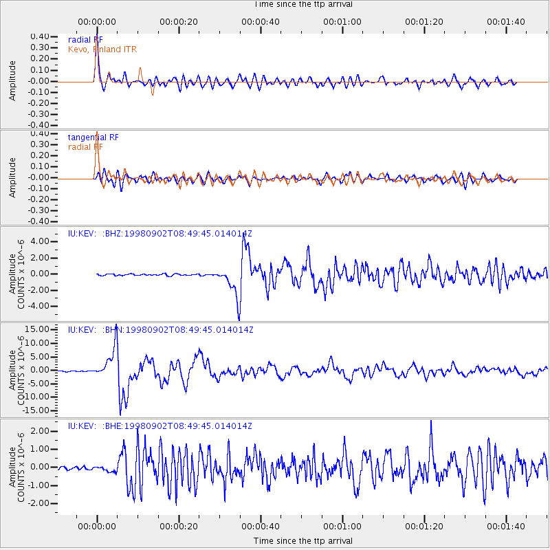
| Earthquake location: |
Mindanao, Philippines |
| Earthquake latitude/longitude: |
5.4/126.8 |
| Earthquake time(UTC): |
1998/09/02 (245) 08:37:29 GMT |
| Earthquake Depth: |
50 km |
| Earthquake Magnitude: |
6.6 MB, 6.7 MS, 6.8 UNKNOWN, 6.8 ME |
| Earthquake Catalog/Contributor: |
WHDF/NEIC |
|
| Network: |
IU Global Seismograph Network (GSN - IRIS/USGS) |
| Station: |
KEV Kevo, Finland |
| Lat/Lon: |
69.76 N/27.01 E |
| Elevation: |
80 m |
|
| Distance: |
88.3 deg |
| Az: |
339.929 deg |
| Baz: |
78.997 deg |
| Ray Param: |
0.042580362 |
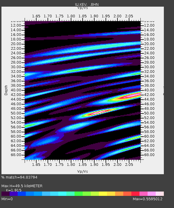
| Estimated Moho Depth: |
49.5 km |
| Estimated Crust Vp/Vs: |
1.91 |
| Assumed Crust Vp: |
6.622 km/s |
| Estimated Crust Vs: |
3.458 km/s |
| Estimated Crust Poisson's Ratio: |
0.31 |
|
| Radial Match: |
94.83794 % |
| Radial Bump: |
400 |
| Transverse Match: |
89.645256 % |
| Transverse Bump: |
400 |
| SOD ConfigId: |
4480 |
| Insert Time: |
2010-03-02 15:36:04.243 +0000 |
| GWidth: |
2.5 |
| Max Bumps: |
400 |
| Tol: |
0.001 |
|
Signal To Noise
| Channel | StoN | STA | LTA |
| IU:KEV: :BHN:19980902T08:49:45.014014Z | 46.180374 | 5.9034783E-6 | 1.2783521E-7 |
| IU:KEV: :BHE:19980902T08:49:45.014014Z | 1.8286806 | 1.5110575E-7 | 8.2631026E-8 |
| IU:KEV: :BHZ:19980902T08:49:45.014014Z | 20.42676 | 1.945437E-6 | 9.523962E-8 |
| Arrivals |
| Ps | 7.0 SECOND |
| PpPs | 21 SECOND |
| PsPs/PpSs | 28 SECOND |


