You are here: Home > Network List > IU - Global Seismograph Network (GSN - IRIS/USGS) Stations List
> Station KEV Kevo, Finland > Earthquake Result Viewer
KEV Kevo, Finland - Earthquake Result Viewer
| Earthquake location: |
Kuril Islands |
| Earthquake latitude/longitude: |
46.5/153.2 |
| Earthquake time(UTC): |
2006/10/01 (274) 09:06:02 GMT |
| Earthquake Depth: |
19 km |
| Earthquake Magnitude: |
6.1 MB, 6.4 MS, 6.6 MW, 6.5 MW |
| Earthquake Catalog/Contributor: |
WHDF/NEIC |
|
| Network: |
IU Global Seismograph Network (GSN - IRIS/USGS) |
| Station: |
KEV Kevo, Finland |
| Lat/Lon: |
69.76 N/27.01 E |
| Elevation: |
80 m |
|
| Distance: |
57.6 deg |
| Az: |
340.585 deg |
| Baz: |
41.302 deg |
| Ray Param: |
0.06334448 |
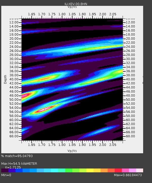
| Estimated Moho Depth: |
54.5 km |
| Estimated Crust Vp/Vs: |
1.71 |
| Assumed Crust Vp: |
6.622 km/s |
| Estimated Crust Vs: |
3.867 km/s |
| Estimated Crust Poisson's Ratio: |
0.24 |
|
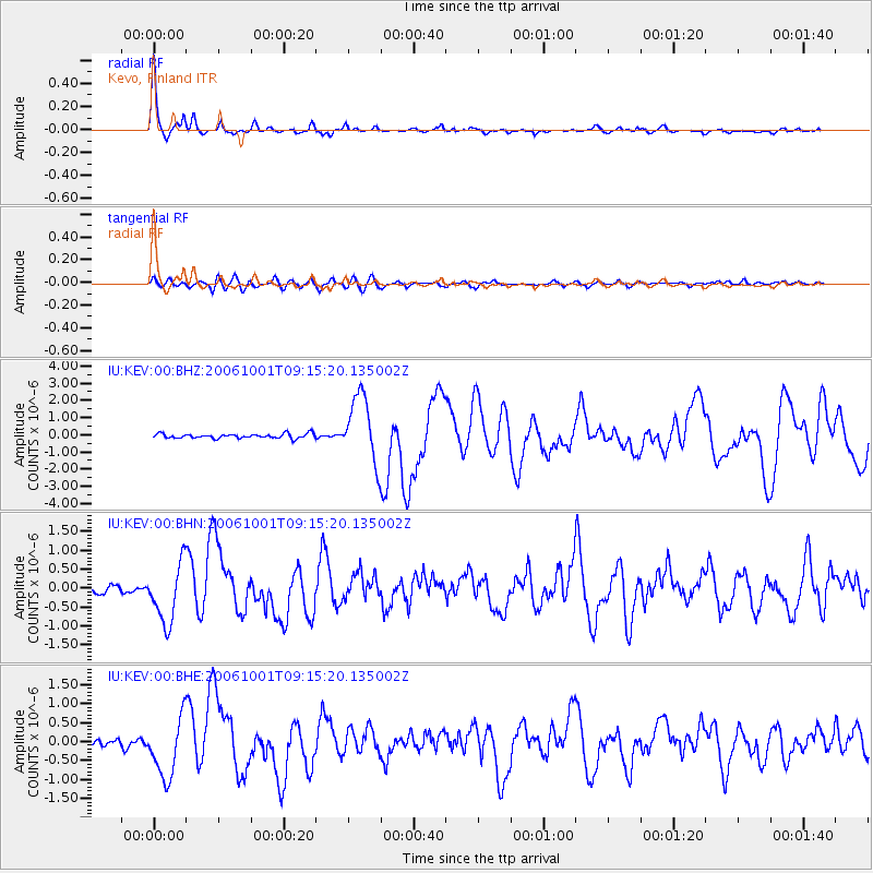
| Radial Match: |
95.04793 % |
| Radial Bump: |
245 |
| Transverse Match: |
78.44588 % |
| Transverse Bump: |
400 |
| SOD ConfigId: |
2665 |
| Insert Time: |
2010-03-02 15:36:27.246 +0000 |
| GWidth: |
2.5 |
| Max Bumps: |
400 |
| Tol: |
0.001 |
|
Signal To Noise
| Channel | StoN | STA | LTA |
| IU:KEV:00:BHN:20061001T09:15:20.135002Z | 7.716964 | 7.7768357E-7 | 1.0077585E-7 |
| IU:KEV:00:BHE:20061001T09:15:20.135002Z | 6.6466036 | 7.852125E-7 | 1.1813741E-7 |
| IU:KEV:00:BHZ:20061001T09:15:20.135002Z | 14.848017 | 1.9322442E-6 | 1.3013485E-7 |
| Arrivals |
| Ps | 6.2 SECOND |
| PpPs | 21 SECOND |
| PsPs/PpSs | 27 SECOND |


