You are here: Home > Network List > IU - Global Seismograph Network (GSN - IRIS/USGS) Stations List
> Station KEV Kevo, Finland > Earthquake Result Viewer
KEV Kevo, Finland - Earthquake Result Viewer
| Earthquake location: |
Washington |
| Earthquake latitude/longitude: |
47.1/-122.7 |
| Earthquake time(UTC): |
2001/02/28 (059) 18:54:32 GMT |
| Earthquake Depth: |
52 km |
| Earthquake Magnitude: |
6.5 MB, 6.6 MS, 6.8 MW, 6.7 ME |
| Earthquake Catalog/Contributor: |
WHDF/NEIC |
|
| Network: |
IU Global Seismograph Network (GSN - IRIS/USGS) |
| Station: |
KEV Kevo, Finland |
| Lat/Lon: |
69.76 N/27.01 E |
| Elevation: |
80 m |
|
| Distance: |
61.3 deg |
| Az: |
11.536 deg |
| Baz: |
336.913 deg |
| Ray Param: |
0.060835272 |
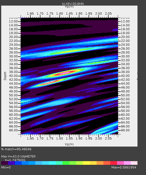
| Estimated Moho Depth: |
43.0 km |
| Estimated Crust Vp/Vs: |
1.75 |
| Assumed Crust Vp: |
6.622 km/s |
| Estimated Crust Vs: |
3.79 km/s |
| Estimated Crust Poisson's Ratio: |
0.26 |
|
| Radial Match: |
95.46046 % |
| Radial Bump: |
390 |
| Transverse Match: |
87.71602 % |
| Transverse Bump: |
400 |
| SOD ConfigId: |
3744 |
| Insert Time: |
2010-03-02 15:38:05.977 +0000 |
| GWidth: |
2.5 |
| Max Bumps: |
400 |
| Tol: |
0.001 |
|
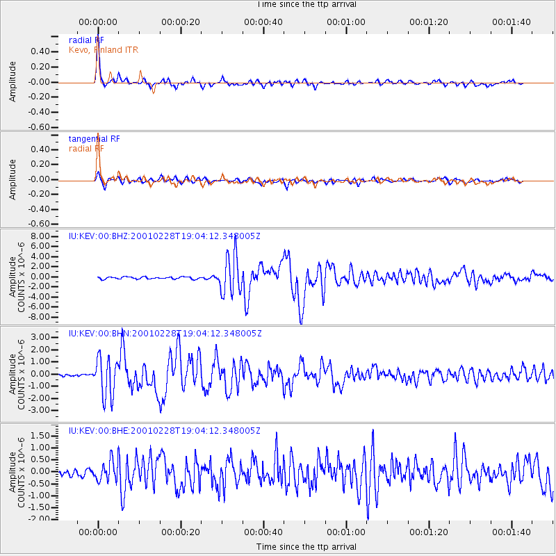
Signal To Noise
| Channel | StoN | STA | LTA |
| IU:KEV:00:BHN:20010228T19:04:12.348005Z | 21.337868 | 1.6322356E-6 | 7.6494786E-8 |
| IU:KEV:00:BHE:20010228T19:04:12.348005Z | 3.486043 | 4.3079297E-7 | 1.2357648E-7 |
| IU:KEV:00:BHZ:20010228T19:04:12.348005Z | 18.15924 | 3.8267035E-6 | 2.1073038E-7 |
| Arrivals |
| Ps | 5.1 SECOND |
| PpPs | 17 SECOND |
| PsPs/PpSs | 22 SECOND |


