You are here: Home > Network List > IU - Global Seismograph Network (GSN - IRIS/USGS) Stations List
> Station XMAS Kiritimati Island, Republic of Kiribati > Earthquake Result Viewer
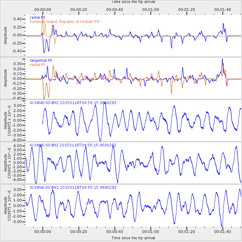
XMAS Kiritimati Island, Republic of Kiribati - Earthquake Result Viewer
*The percent match for this event was below the threshold and hence no stack was calculated.
| Earthquake location: |
Rat Islands, Aleutian Islands |
| Earthquake latitude/longitude: |
51.9/179.6 |
| Earthquake time(UTC): |
2015/01/18 (018) 04:47:38 GMT |
| Earthquake Depth: |
106 km |
| Earthquake Magnitude: |
5.8 MB, 5.9 MB |
| Earthquake Catalog/Contributor: |
NEIC PDE/NEIC COMCAT |
|
| Network: |
IU Global Seismograph Network (GSN - IRIS/USGS) |
| Station: |
XMAS Kiritimati Island, Republic of Kiribati |
| Lat/Lon: |
2.04 N/157.45 W |
| Elevation: |
20 m |
|
| Distance: |
53.3 deg |
| Az: |
150.867 deg |
| Baz: |
342.434 deg |
| Ray Param: |
$rayparam |
*The percent match for this event was below the threshold and hence was not used in the summary stack. |
|
| Radial Match: |
62.883396 % |
| Radial Bump: |
400 |
| Transverse Match: |
48.9153 % |
| Transverse Bump: |
315 |
| SOD ConfigId: |
837871 |
| Insert Time: |
2015-02-01 05:08:23.620 +0000 |
| GWidth: |
2.5 |
| Max Bumps: |
400 |
| Tol: |
0.001 |
|
Signal To Noise
| Channel | StoN | STA | LTA |
| IU:XMAS:00:BHZ:20150118T04:56:15.969028Z | 1.4026216 | 2.2322324E-6 | 1.5914717E-6 |
| IU:XMAS:00:BH1:20150118T04:56:15.969028Z | 0.79686004 | 1.3537044E-6 | 1.6987982E-6 |
| IU:XMAS:00:BH2:20150118T04:56:15.969028Z | 1.9420869 | 2.8598722E-6 | 1.4725769E-6 |
| Arrivals |
| Ps | |
| PpPs | |
| PsPs/PpSs | |


